
The upland regions of Cebu represent the island’s watersheds, recharge zones, forests, limestone formations, and mineral deposits. These regions are the ecological backbone of the province. These areas perform critical hydrological functions, anchor biodiversity, and mitigate the worst impacts of storms, flooding, and extreme weather events. Yet, from a political economy perspective, the control, use, and allocation of upland spaces reveal deep asymmetries of power. There are persistent institutional weaknesses. Long-standing tensions exist between economic extraction and ecological stability. Understanding who controls the uplands is essential. Additionally, knowing how these controls shape risks and vulnerabilities is crucial. This knowledge helps explain why Cebu is increasingly prone to catastrophic flooding. Moreover, it explains the occurrences of slope failures.
Historically, Cebu’s uplands were governed under a fragmented regime of land classifications. These included forestlands, timberlands, alienable and disposable lands, ancestral domains, and protected areas. This system was established by national decrees and colonial land laws. Presidential Decree No. 705 (Revised Forestry Code) and Presidential Decree No. 1998 put most upland forests under State ownership. This pertains to lands with an eighteen percent slope or more in the provinces of Cebu and Benguet. However, weak enforcement gradually eroded these controls. Unregulated settlements and local political brokerage also contributed to this erosion.
In the 1980s and 1990s, selective logging, quarrying, and small-scale mineral extraction expanded. These activities were often facilitated by patronage ties. The growing political influence of local business groups also played a role. Super Typhoon Ruping (Typhoon Mike) struck in November 1990. It demolished 60% of Cebu’s buildings. Additionally, it displaced over 80,000 people in the province and sank 88 ships in Cebu Harbor. This should have been a watershed moment for upland governance. Yet despite the catastrophe, extractive pressures not only continued but also intensified. This occurred in the decades that followed. Quarrying and mining became intertwined with urban growth, cement production, and construction demand.
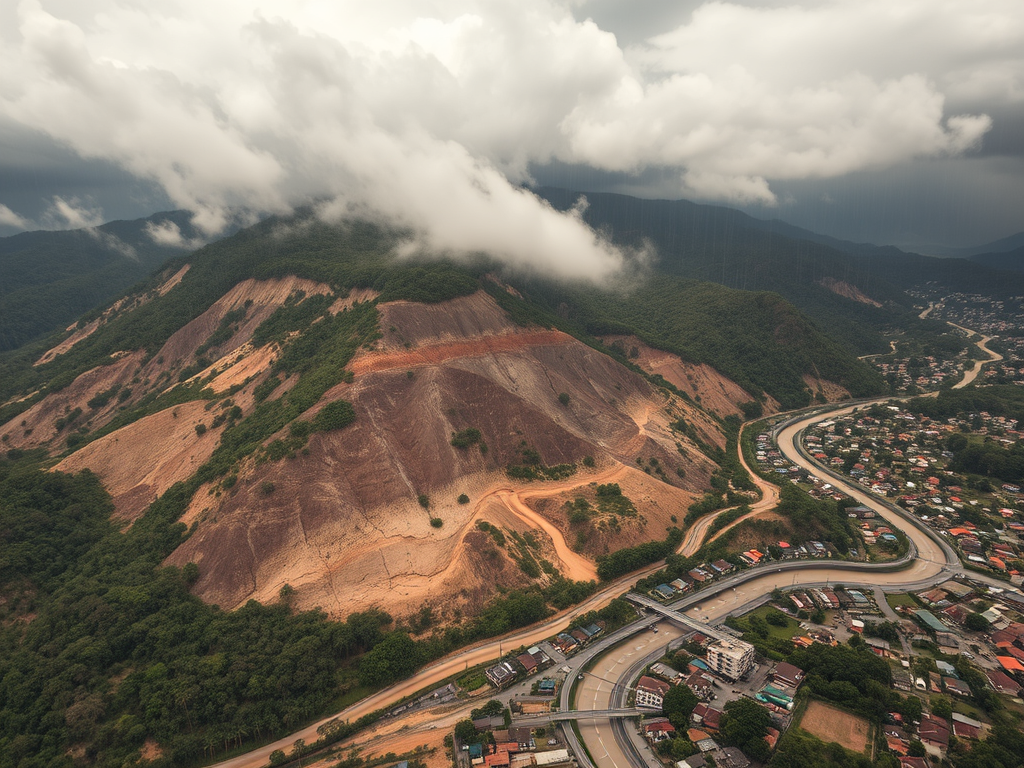
An examination of official records shows that Cebu’s uplands today are substantially shaped by the extractive sector. Based on the Directory of Operating Mines and Quarries (2024), the province has 81 active quarry and mining operators. They cover a total of 31,853.0599 hectares. This footprint exceeds the combined land areas of several Cebu municipalities. These operators extract a wide range of commodities. The commodities include limestone, shale, basalt, greywacke, clay, dolomite, and bentonite. They also extract sandstone, copper, gold, and silver.
Large-scale corporate players dominate, among them Republic Cement & Building Materials Inc. These include Solid Earth Development Corporation and Apo Land & Quarry Corporation. South Western Cement Corporation and Dolomite Mining Corporation also play a role. Additionally, there are Carmen Copper Corporation and JLR Construction & Aggregates Corporation. Their operations span from Asturias and Danao to Naga and Toledo. They also operate in Malabuyoc, San Fernando, Alcoy, Dalaguete, and Minglanilla. These operations cover vast sections of Cebu’s upland landscapes.
These companies hold long-term Mineral Production Sharing Agreements (MPSAs). Some of them extend into the year 2048. An example is the 607-hectare operation of Quarry Ventures Phils., Inc. The largest individual MPSAs include 2,551 hectares (Republic Cement – Danao & Carmen) and 2,383 hectares (Republic Cement – Asturias). Other significant MPSAs are 1,492 hectares for Solid Earth – San Fernando. 648 hectares are for Carmen Copper – Toledo. 524 hectares are for Dolomite Mining – Alcoy & Dalaguete. From a political economy standpoint, long-term control over upland spaces has significant implications. These mineral extraction regimes have locked in decades of upland land use patterns. This process effectively privileges corporate economic interests over watershed protection. It also undermines forest integrity and climate resilience.
This raises fundamental questions: Who benefits from the current upland configuration, and who suffers from its consequences? The primary beneficiaries are, unsurprisingly, the large corporations with long-term extraction rights. They benefit from mineral resources, cement production, and quarrying royalties. These corporations also gain from upland-to-lowland value chains. Local governments also generate revenues from extraction fees, business taxes, and employment opportunities, albeit often limited to short-term financial gains.
However, upland communities bear the environmental and social costs disproportionately. So do downstream barangays, riverine settlements, and informal households. Ultimately, the broader Cebuano public is affected as well. These populations endure increased flooding, faster runoff, declining groundwater recharge, degraded watershed capacity, and heightened risks of landslides and subsidence.
The pattern becomes even clearer when viewed against Cebu’s recent experience with disasters. In the last two decades, the province suffered recurrent catastrophic events. These include floods in Mandaue and Cebu City (2020, 2024), and multiple landslides. The deadly 2018 Naga City landslide killed at least 53 people. These events underscore a disturbing trajectory: hydrological systems strained by decades of upland extraction are progressively failing. Typhoon Kalmaegi (“Tino”) struck Cebu in November 2025. It caused some of the worst flooding in local history. Dozens were dead, thousands displaced, and the lowlands were submerged. This made the role of altered upland landscapes indisputable. And yet, the political economy driving upland control remains intact.
Super Typhoon Ruping serves as a historical anchor for understanding this trajectory. Ruping revealed, as early as 1990, the catastrophic vulnerability of Cebu’s built and ecological systems. The storm’s devastation was immense. It flattened structures, disabled utilities, and caused unparalleled maritime losses. These impacts were rooted in a combination of extreme climatic hazard and fragile landscape integrity. The subsequent “CEBOOM” era of reconstruction accelerated economic growth. However, it did not adequately address upland deforestation. There were also shortcomings in addressing watershed degradation and land-use mismanagement. What followed was a pattern in which Cebu’s economic expansion deepened its ecological vulnerability.
Thus, a political economy analysis of Cebu’s flooding problem is necessarily an analysis of upland control. State authority, corporate extraction, and local political networks are involved. Land use decisions and regulatory gaps play a role too. Together, they have produced a landscape where the uplands—meant to protect the island from hydrological extremes—have been systematically weakened. The result is a province increasingly exposed to the combined pressures of climate change, urban expansion, and ecological degradation.
Addressing Cebu’s flooding crisis requires engineering interventions and urban drainage upgrades. It also demands a structural rethinking of upland governance. This includes a reassessment of long-term extraction contracts, stricter enforcement of environmental laws, transparent land-use planning, and hazard-informed zoning. Additionally, public welfare must be prioritized over private extraction.
The question of who controls the uplands is not merely academic. It is central to Cebu’s survival in an era of intensifying climate risks.
