Beyond Land and Infrastructure: Rethinking the Valuation of Water-Dependent Enterprises

By Augusto B. Agosto, JD, EnP, Economist, Consultant

When most people think of property valuation, they picture land, buildings, machinery, and infrastructure—tangible assets that can be easily inspected, measured, and compared in the marketplace. For water-dependent enterprises, however, a more fundamental question often arises: What is the value of the resource that makes the entire enterprise possible?

A water treatment plant without water has little utility; pipelines without water cannot generate revenue; and reservoirs without water are merely empty storage facilities. Yet, traditional valuation approaches often focus heavily on physical assets while giving limited attention to the underlying resource and the legal rights that govern access to it.

Recent professional engagements involving bulk water supply systems, utility infrastructure, and water-related enterprises prompted me to revisit a question that sits precisely at the intersection of law, economics, environmental planning, and valuation: Can the value of a water enterprise be fully explained by land and physical improvements alone? The answer is considerably more complex than conventional appraisal practice suggests.

Who Owns the Water?

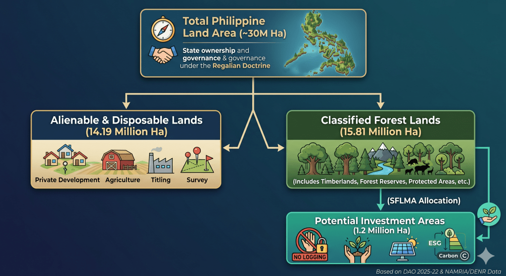
The starting point of any discussion on water rights in the Philippines is the Regalian Doctrine. Under Article XII, Section 2 of the Constitution, all natural resources—including waters—belong to the State. The Water Code of the Philippines (Presidential Decree No. 1067) further reinforces this by declaring that private entities may acquire only the right to appropriate and utilize water, subject to strict state regulation.

This distinction is critical for valuation professionals: private entities generally do not own the water itself. Instead, they acquire the legal authority to access, extract, treat, distribute, and utilize water for beneficial purposes. While a water permit is merely an administrative authorization from a legal perspective, from an economic perspective, that authorization represents a monumental source of value.

Water Rights as Economic Assets

Economics teaches us that value arises from scarcity. Although the Philippines is traditionally viewed as an island nation rich in water resources, many regions face acute water stress driven by population growth, rapid urbanization, watershed degradation, groundwater depletion, and climate-induced seasonal variability. As access to reliable water becomes premium, the economic significance of water rights increases proportionally.

Water rights act as economic catalysts by providing:

  • Access to a Scarce Resource: Guaranteed entry into a restricted natural market.
  • Security of Supply & Legal Certainty: Risk mitigation against operational disruptions and litigation.
  • Priority of Use & Investment Opportunities: The baseline confidence required to deploy heavy capital for infrastructure development.

In effect, water rights serve as the operational bridge that converts unpriced natural resources into productive, revenue-generating economic assets.

Lessons from Practice: Beyond Tangible Assets

Several recent valuation assignments involving watershed-based bulk water supply systems and utility infrastructure projects forced a departure from standard real estate appraisal. These engagements required an evaluation that looked beyond physical infrastructure to assess raw water sources, regulatory authorizations, off-take contractual arrangements, and long-term hydrological sustainability.

One particular assignment involving a watershed-based bulk water supply system raised several non-traditional questions:

  • What precise portion of enterprise value is truly attributable to land versus physical improvements?
  • How should the raw, productive capacity of the surrounding watershed be quantified?
  • What is the isolated economic value of the right to abstract and distribute water?
  • How does the long-term reliability of the water source impact overall enterprise risk and value?
  • To what extent do administrative permits and contractual off-take agreements contribute to the ongoing economic viability of the operation?

Answering these questions required moving past conventional property appraisal and venturing into resource economics, institutional rights, environmental planning, and natural capital accounting. The valuation ultimately demonstrated that the economic performance of the enterprise could not be explained solely by its tangible assets. A massive portion of its utility and income-generating capacity was inherently tied to the underlying water resource and the institutional frameworks safeguarding access to it.

Two Paths to Water Production

Observation of water enterprises in Cebu reveals an interesting operational dichotomy. Different enterprises produce marketable water through completely different asset profiles:

Production TypologyResource ReliancePrimary Value Driver
Natural Capital-DependentWatersheds, springs, and deep groundwater systems.High reliance on natural replenishment and ecological health.
Technology-DependentDesalination plants and advanced treatment systems converting seawater or brackish water.High reliance on produced capital, energy inputs, and technological investments.

While both typologies generate revenue by delivering the same end product, their underlying asset structures differ fundamentally. One depends heavily on natural ecosystems; the other depends on engineered physical infrastructure. Yet, both share the same economic reality: without access to the baseline water resource (whether raw fresh water or raw seawater), neither infrastructure nor technology can generate revenue.

Natural Capital and Water Resources

The emerging field of natural capital accounting provides a precise framework for modernizing valuation practice. Natural capital refers to natural assets capable of generating flow-of-resource economic benefits. In this context, it encompasses:

  • Watersheds, aquifers, and natural springs.
  • Rivers, recharge areas, and critical forest ecosystems that regulate hydrological cycles.

Without healthy watersheds and functioning hydrological systems, physical water supply infrastructure loses its utility. Consequently, the comprehensive valuation of water enterprises demands that we look upstream at the sustainability and ecological health of the resource provider.

Beyond Valuation: Understanding How Water Creates Economic Value

The appraisal of water-dependent enterprises often begins as a valuation exercise. However, the analysis quickly extends beyond traditional questions of market value and into a broader examination of how value is created.

Water enterprises derive their economic significance not merely from land, infrastructure, or equipment, but from the interaction of natural resources, institutions, and markets. Watersheds generate water resources. Legal and regulatory systems allocate access through water rights and permits. Infrastructure transforms the resource into a usable product. Markets create demand. Together, these elements produce economic value.

Viewed from this perspective, water rights valuation is not simply an appraisal problem. It is fundamentally an economic inquiry into how natural capital is transformed into productive capital through institutional arrangements and investment.

The valuation question therefore becomes a gateway to a broader understanding of resource economics, natural capital, and economic development.

Recent developments—including the enactment of the Philippine Ecosystem and Natural Capital Accounting System (PENCAS), the Philippine Statistics Authority’s Water Accounts, and ongoing national water resource assessments—reflect a growing recognition that natural resources are not merely environmental assets but fundamental contributors to economic development and national wealth.

These initiatives have significantly advanced the measurement of water resources, ecosystem services, and natural capital. However, an important gap remains. Much of the existing literature focuses on water availability, water use, allocation, pricing, and conservation. Far less attention has been devoted to understanding how water resources create economic value and how institutional arrangements governing access to those resources influence investment, enterprise development, and wealth creation.

In particular, limited research has examined the role of water rights as institutional mechanisms that transform water resources into productive economic assets. The interaction between natural capital, legal entitlements, infrastructure investment, and economic production remains largely unexplored in the Philippine context. Understanding this relationship is increasingly important as water scarcity, climate risks, and competing resource demands place greater emphasis on the economic significance of water resources.

These questions form the foundation of the author’s ongoing research, which seeks to examine how scarcity, institutions, and water rights interact to create economic value within water-dependent enterprises and, more broadly, within the Philippine economy.

Conclusion

The discussion on water rights ultimately leads to a broader question than valuation itself. While appraisal seeks to measure value, economics seeks to understand how value is created. In the case of water-dependent enterprises, the answer extends beyond land, buildings, treatment facilities, and infrastructure.

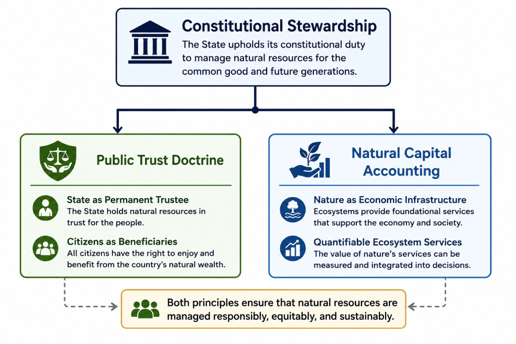
The experience of examining bulk water systems suggests that economic value originates from the interaction of natural capital, institutions, and investment. Watersheds, aquifers, springs, and other water resources provide the physical foundation. The State, through the Regalian Doctrine and the Water Code, establishes the institutional framework governing access and allocation. Water rights and permits create certainty, enabling investment in infrastructure, treatment systems, and distribution networks that transform natural resources into economic output.

Viewed from this perspective, water rights are more than regulatory instruments. They serve as institutional mechanisms that connect natural capital to economic production. Understanding their role requires moving beyond traditional discussions of water use and toward a deeper examination of how water resources contribute to enterprise value, regional development, and national wealth.

Recent initiatives such as PENCAS, the PSA Water Accounts, and national water resource assessments signal a growing recognition of the economic importance of natural assets. Yet important questions remain. How do watersheds create economic value? How do institutions influence the allocation of scarce water resources? How do water rights support investment, productivity, and long-term development? These questions remain largely unexplored within Philippine literature and present opportunities for future research.

The inquiry that began as a valuation problem has therefore evolved into a broader economic question: how does a water resource become economic value? Exploring that question may not only improve valuation practice but also contribute to a deeper understanding of water governance, natural capital, and sustainable development in the Philippines. As water scarcity and climate-related challenges become increasingly significant, the ability to understand and account for the value created by water resources may prove essential to both economic policy and resource management in the decades ahead.

SFLMA and the Future of Environmental Asset Governance in the Philippines

I. Introduction

The implementation of the Sustainable Forest Land Management Agreement (SFLMA) under DENR Administrative Order No. 2025-22 marks a transformative shift from traditional, defensive forestry toward active environmental asset governance. This reform takes place against a complex legal backdrop where approximately 15.81 million hectares—over half of the Philippines’ total 30-million-hectare landmass—remain classified as public forest lands under the constitutional mandate of the Regalian Doctrine.

Historically, this system has suffered from institutional inertia, leaving official land boundaries largely unchanged since 2006 and creating a severe mismatch between legal designations and actual land use on the ground. However, the rise of the modern carbon economy has fundamentally reframed these spaces. Rather than treating forests merely as passive timber reserves or off-limits ecological zones, the SFLMA framework targets 1.2 million hectares of degraded public land—distributed across roughly 1,700 mapped parcels—to serve as climate infrastructure, carbon reservoirs, and natural capital assets.

Ultimately, this initiative places Philippine land governance at a critical intersection. The central challenge moving forward is balancing market-driven climate investments and carbon governance with the enduring constitutional principles of stewardship, social justice, and intergenerational responsibility.

II. The Carbon Economy and Legal Consolidation

One of the most consequential dimensions of the SFLMA is its architectural role in the emerging carbon economy. As international compliance and voluntary carbon markets mature, the framework provides the administrative and tenurial foundation required to host land-based carbon projects, verify forest carbon sequestration, and generate tradable carbon credits.

By offering long-term tenurial security, the SFLMA lowers the political and regulatory risk for institutional investors looking to fund nature-based solutions (NbS). Reforestation projects under this framework are uniquely positioned to serve as high-quality carbon sinks capable of issuing verified offsets for both domestic and international transfer.

Furthermore, this framework serves a critical state interest in regulatory streamlining. The SFLMA replaces and consolidates older, fragmented forest tenure systems, officially retiring:

  1. Industrial Forest Management Agreements (IFMA)
  2. Socialized Industrial Forest Management Agreements (SIFMA)
  3. Select commercial components of Community-Based Forest Management Agreements (CBFMA)

By collapsing these disparate instruments into a single governance mechanism, the DENR aims to eliminate conflicting land-use mandates, minimize institutional red tape, and lower transaction costs for clean-energy and conservation proponents. As the DENR noted during its rollout, the framework is explicitly designed to simultaneously generate rural employment, stimulate local economies, and boost the national gross domestic product (GDP) through sustainable forest enterprises.

III. Operationalizing SFLMA through the PENCAS Act

To properly realize its potential, the SFLMA framework must be linked directly to Republic Act No. 11995, otherwise known as the Philippine Ecosystem and Natural Capital Accounting System (PENCAS) Act. Passed to institutionalize the internationally accepted System of Environmental-Economic Accounting (SEEA), PENCAS provides the statutory framework that turns the theory of “environmental asset governance” into measurable fiscal and physical data.

┌────────────────────────────────────────────────────────┐
│ R.A. 11995 (PENCAS Act) │
│ National Macroeconomic & Data Standards │
└───────────────────────────┬────────────────────────────┘
▼ (Provides Baselines & Metrics)
┌────────────────────────────────────────────────────────┐
│ DENR DAO No. 2025-22 (SFLMA) │
│ Project-Level Allocation & Concessions │
└────────────────────────────────────────────────────────┘

1. The Data Engine for Asset Valuations

While the SFLMA identifies 1.2 million hectares of Potential Investment Areas (PIAs) for carbon sequestration and ecosystem services, establishing their baseline value without a standardized legal methodology invites speculation. The PENCAS Act solves this challenge by mandating the collection and compilation of official statistics on the depletion, degradation, and restoration of natural capital.

  • Asset Accounts: Under PENCAS, the state must maintain strict physical and monetary accounts of timber and land assets, which directly inform SFLMA baseline data. This guarantees that carbon sequestration projects calculate genuine additionality rather than relying on unverified corporate metrics.
  • Quantifying Ecosystem Services: PENCAS legalizes the valuation of “regulating services”—such as carbon storage, water filtration, and flood protection—giving SFLMA proponents a government-sanctioned data framework to back up ESG investments and carbon-credit accounting.

2. Macroeconomic Integration vs. Project-Level Finance

Under R.A. 11995, natural capital statistics are integrated directly into the country’s macroeconomic indicators, meaning major environmental accounts are co-released with traditional economic indicators like GDP. This creates a dual-layered governance system: PENCAS operates at the macro-level to track nature’s aggregated wealth, while the SFLMA operates at the micro-tenurial level. The SFLMA serves as the contractual vehicle allowing private and community actors to manage specific plots of land using the uniform accounting standards established under PENCAS.

3. Verification and Safeguards Against Greenwashing

One of the primary critiques of the SFLMA is the high risk of greenwashing and corporate regulatory capture. The PENCAS Act introduces a critical check on this through its institutionalized accounting metrics. If an SFLMA concessionaire causes ecosystem degradation or implements biodiversity-poor monoculture plantations under the guise of carbon offsets, the localized reduction in ecosystem asset accounts provides public interest litigants with actionable, government-backed data to support petitions for environmental remedies, such as a Writ of Kalikasan.

IV. Constitutional Boundaries: The Public Trust Intersection

Despite its market-oriented mechanics, the SFLMA operates within rigid constitutional boundaries. Under Section 2, Article XII of the 1987 Philippine Constitution, all lands of the public domain and natural resources belong to the State under the Regalian Doctrine (Jura Regalia). Because public forest lands are inalienable, the SFLMA does not transfer ownership. Instead, it grants restricted stewardship and management rights, explicitly conditioned upon the continuous fulfillment of environmental obligations.

This arrangement operationalizes the constitutional philosophy that property bears a social function, meaning the right to utilize natural resources is inherently subordinated to the welfare of the common good. Consequently, the SFLMA sits at a complex legal intersection:

Under the Public Trust Doctrine, the State serves as the perpetual trustee of the nation’s natural wealth, while private and community actors function as temporary, fiduciary stewards. Every SFLMA project must therefore operate within legally defined ecological limits, ensuring that the exploitation of the asset does not impair the underlying public trust.

V. Systemic Risks, Drawbacks, and Structural Critiques

While structurally ambitious, the SFLMA framework exhibits several vulnerabilities, regulatory gaps, and socio-ecological risks that require rigorous mitigation.

1. The Commercialization of Ecospace and Greenwashing

By treating forests as natural capital, there is an immediate risk that environmental governance becomes subordinated to market incentives. If forests are valued primarily for their carbon credit yields and commercial ESG returns, biodiversity and deep ecological integrity may take a backseat.

This commercial focus invites structural greenwashing. Without robust, third-party verification protocols and data-driven carbon audit registries, corporate actors might exploit SFLMA concessions as cheap corporate branding vehicles. Weak state oversight could lead to speculative carbon banking, double-counting of offsets, and the generation of low-integrity carbon credits that fail to achieve genuine additionality.

2. Corporate Concession Dominance and Elite Capture

The framework permits large-scale corporate participation, allowing single entities to hold management rights over extensive tracts of land—in some instances up to 40,000 hectares. This high ceiling raises significant concerns regarding elite capture and land concentration. If large conglomerates dominate the competitive allocation of Potential Investment Areas (PIAs), smaller cooperatives, local civil society organizations, and marginalized upland communities may be priced out of the environmental asset market entirely.

3. Overlaps with Ancestral Domains and IP Exploitation

Spatial mapping data from the DENR indicates a critical geographic tension: approximately 85% of identified SFLMA parcels partially overlap with roughly 15% of ancestral domains occupied by Indigenous Cultural Communities (ICCs) and Indigenous Peoples (IPs).

While the law mandates compliance with the Free and Prior Informed Consent (FPIC) process under the Indigenous Peoples’ Rights Act (IPRA), there is a structural risk that this participation becomes merely transactional or symbolic. If indigenous communities lack equal bargaining power or sophisticated legal representation, they may find themselves excluded from meaningful benefit-sharing mechanisms and long-term project governance.

4. Ecological Conversion and Monoculture Risks

From an ecological standpoint, carbon-sequestration math often favors fast-growing, non-native commercial species over complex, slow-growing native silviculture. Policy research from the University of the Philippines warns that if regulatory safeguards are weak, the SFLMA could inadvertently incentivize the conversion of remaining natural secondary forests into simplified agroforestry or monoculture plantation systems, compromising local biodiversity and watershed resilience in the name of carbon maximization.

5. Regulatory Capture and Institutional Capacity Gaps

Simultaneously managing and auditing more than one million hectares of geographically dispersed forest lands demands an unprecedented level of technical, technological, and regulatory oversight. The DENR currently faces significant budgetary, staffing, and technological constraints. Without advanced remote sensing, real-time drone monitoring, and corruption-resistant auditing platforms, the SFLMA framework remains vulnerable to regulatory capture, illicit land conversions, and enforcement failures on the ground.

VI. Conclusion: Anchoring the Future Framework

The SFLMA brings a foundational tension in modern environmental law to the forefront: Should nature be governed primarily as an inviolable public trust, or as a quantifiable economic asset?

The doctrinal significance of DAO No. 2025-22 lies in its attempt to merge these two paradigms. It demonstrates that the Philippines is actively transitioning from a legacy of reactive environmental regulation to a proactive strategy of environmental asset governance.

The policy challenge moving forward is not whether the Philippines should participate in global climate finance or build domestic carbon markets; rather, it is whether these market mechanisms can remain firmly anchored to constitutional stewardship, social justice, and the principle of intergenerational responsibility (Oposa v. Factoran).

The ultimate success of Philippine carbon governance will depend on the state’s ability to develop a comprehensive legal framework that balances private economic utilization with robust public accountability, ensuring that all environmental assets are managed to serve the common good. The SFLMA has opened the door to market-based conservation; the onus is now on the state, civil society, and private sector to build the governance architecture required to walk through it responsibly.

Selected references and links:

Monterrazas and the Tragedy of the Commons

Why System Thinking Requires Stricter Development Standards

Recent public discussions have reflected different perspectives on the Monterrazas development in Cebu City, including system-level explanations, precautionary considerations, and calls for regulatory review. These illustrate the complexity of decision-making in such contexts.

At first glance, the issue may appear as a familiar tension between development and environmental protection. However, it may be more accurately understood through a different lens.

From an economic perspective, what this situation reflects is a form of the Tragedy of the Commons.

The concern lies in understanding how multiple developments interact within a shared system, and how each contributes to cumulative impacts over time.

Cebu’s upland areas perform essential ecological functions. They absorb rainfall, regulate runoff, and contribute to the stability of downstream communities. These functions do not operate within the boundaries of individual properties. They extend across space, linking different parts of the city through continuous hydrological processes.

In this context, the question of whether a particular development lies within or outside a defined watershed boundary, while relevant in technical terms, does not fully resolve the issue. Environmental systems do not operate as isolated compartments. Their behavior reflects interaction rather than separation.

The scale of that interaction is often difficult to grasp in abstract terms.

Evidence from watersheds within Metro Cebu further clarifies how this system operates—and how development must be understood within it.

Studies of the Mananga watershed show that land-use and land-cover changes—particularly in upstream areas—affect infiltration, surface runoff, and the movement of water across the system. As vegetation is reduced or land is altered, less water is absorbed and more becomes surface flow.

A similar pattern is observed in the Butuanon River watershed. The river originates in upland areas of Cebu City and flows through increasingly urbanized zones before reaching the coast. Upstream areas are already characterized by agricultural and altered land uses, while downstream sections are densely developed. This configuration illustrates how water accumulates as it moves across elevations, shaped by both upstream conditions and downstream constraints.

Altogether, these cases point to a consistent principle:

The watershed is the system within which individual projects must be considered, as runoff is generated across the entire catchment while its behavior is shaped by land-use conditions across different elevations.

This framing is critical. It does not assign causation to any single location. Rather, it defines the proper unit of analysis.

A project is not evaluated in isolation, but in relation to the system it enters—where each intervention contributes to cumulative pressures and must therefore be assessed with reference to the system’s capacity.

It is often observed that flooding in Cebu is multi-causal. Infrastructure limitations, watershed conditions, land-use changes, and rainfall patterns all contribute. This observation is correct.

However, its implication must be properly understood.

If multi-causality is interpreted to mean that no single development can be meaningfully evaluated, then responsibility becomes diffused. Multiple factors contribute, yet accountability becomes less clearly defined.

But the correct implication is the opposite.

If risk is systemic, then evaluation must also be systemic—and correspondingly more rigorous.

The system is not an excuse—it is the basis for stricter evaluation.

This requires a shift in how development decisions are made.

The relevant question is not whether a particular project can be shown to cause a specific flooding event. Rather, it is whether the addition of that project contributes, in combination with others, to increasing pressure on a system that may already be approaching its limits.

The concern lies in the combined effects within a shared system, and in how each individual project contributes to those cumulative impacts.

This leads to a central question:

What is the capacity of the system?

How many developments are already present within a given environmental zone?
To what extent has land use already been altered?
At what point does additional development begin to significantly affect the system’s ability to absorb rainfall and regulate runoff?

Without a clear understanding of these limits, development decisions are made incrementally, without reference to cumulative thresholds.

The Monterrazas issue, therefore, should be viewed in terms of how development decisions are made when each additional project contributes to a system with finite capacity.

In such a context, compliance at the project level is no longer sufficient. Each additional intervention must be evaluated in relation to the condition of the system as a whole.

This has significant implications for urban development.

First, evaluation must move beyond individual projects toward system-level analysis.

Second, development must be aligned with capacity. Growth is no longer simply a matter of feasibility or compliance, but of whether the system can sustain additional pressure.

Third, planning must shift from reactive to anticipatory. Addressing impacts only after they occur is both inefficient and costly.

Fourth, institutional coordination must ensure that decisions reflect a consistent understanding of cumulative risk.

The Monterrazas issue is not resolved by determining whether it falls within a particular boundary, nor by isolating it from broader conditions.

It must be understood as part of a system where effects accumulate, capacity is finite, and each development contributes to increasing pressure on that system.

It shows that outcomes in shared systems are shaped not only by individual decisions, but by how those decisions accumulate—and whether they are governed by a clear understanding of limits.

Ultimately, the question is not whether a particular project should proceed or not.

It is whether each project is evaluated in light of the system it enters—and whether that system can sustain the additional burden it brings.

Because in such systems, urban development is no longer simply about what can be built.

It is about how each development contributes to a shared environment—and whether the whole remains within its capacity to endure.

Natural Capital Accounting and the Apo Quarry Case

The recent tax dispute between the Province of Cebu and Apo Land and Quarry Corporation (ALQC) has highlighted the legal limits of provincial taxation authority over quarry operations. The initial assessment of approximately Php1.218 billion was reduced to a proposed Php211 million compromise settlement, now under review by the Provincial Board. While the legal aspects of the dispute revolve around statutory limits on quarry taxation, the case also raises a broader question: how should the economic value of natural landscapes affected by quarry extraction be measured?

The Philippines has recently institutionalized ecosystem and natural capital accounting through Republic Act No. 11995, commonly referred to as PENCAS. This law recognizes ecosystems as economic assets whose value should be reflected in national and local policy decisions. When applied to quarry operations, natural capital accounting allows policymakers to estimate the economic value of ecosystem services that may be affected by extraction activities.

Under the PENCAS framework, the economic value of a natural resource landscape can be expressed as the Total Economic Value, which combines both market output and ecosystem services.

ComponentDescription
Market valueCommercial value of extracted minerals
Natural capital valueEcosystem services such as watershed protection, slope stabilization, and flood mitigation

While traditional taxation captures only the market value of extraction, natural capital accounting attempts to quantify the value of ecosystem functions that support environmental stability and community resilience.

The Apo quarry operations cover an estimated 406 hectares under mining agreements. However, quarry sites typically disturb only a portion of the concession area at any given time. International mining and quarrying studies suggest that active disturbance commonly affects 30–40 percent of the concession area. Applying a mid-range estimate of 35 percent disturbance, the approximate area of affected landscape may be calculated as follows:

IndicatorValue
Total concession area406 hectares
Estimated disturbance ratio35%
Estimated disturbed area142 hectares

Global watershed valuation studies—including the The Economics of Ecosystems and Biodiversity (TEEB) Initiative and the widely cited work of Costanza et al. (2014) Changes in the Global Value of Ecosystem Services—estimate the bundled value of ecosystem services such as watershed protection, flood regulation, erosion control, and groundwater recharge at approximately US$3,000 to US$20,000 per hectare per year depending on ecosystem type.

Also, ecosystem service valuation studies conducted in watershed environments worldwide estimate the value of environmental services such as flood regulation, erosion control, and groundwater recharge at approximately US$10,000–US$20,000 per hectare annually. Converting this range into Philippine pesos results in an estimated Php500,000 to Php1,000,000 per hectare per year.

Using a conservative midpoint estimate of Php900,000 per hectare annually, the potential ecosystem service value associated with the affected landscape may be estimated as follows:

CalculationValue
Disturbed area142 hectares
Estimated ecosystem value per hectarePhp900,000/year
Estimated ecosystem service valuePhp127.8 million per year

This estimated ecological value offers a useful point of comparison with the proposed compromise settlement in the Apo tax case. If the Php211 million settlement is distributed across the approximate 16-year coverage period of the assessment, the provincial fiscal recovery corresponds to roughly Php13.2 million per year.

The comparison between fiscal recovery and estimated ecosystem value may be illustrated as follows:

IndicatorEstimated Value
Ecosystem services valuePhp127.8 million / year
Provincial fiscal recoveryPhp13.2 million / year
Fiscal capture ratio≈10% of ecosystem value

It is important to emphasize that this comparison does not imply a legal liability on the part of the quarry operator. Rather, it illustrates the difference between the fiscal instruments currently available to local governments and the broader environmental value associated with landscapes affected by extraction activities.

Mining agreements in the Philippines typically operate within a 25–30 year timeframe. If the estimated ecosystem service value were projected over a 30-year operational horizon, the cumulative value of ecosystem services associated with the affected landscape could be estimated as follows:

ProjectionValue
Annual ecosystem valuePhp127.8 million
30-year horizon Estimated ecosystem valuePhp3.8 billion

This simplified natural capital ledger helps place the Apo quarry case within a broader economic context.

ComponentEstimated Value
Limestone production value (Cebu quarry sector)~Php225 million/year
Ecosystem service value~Php128 million/year
Estimated 30-year ecosystem value~Php3.8 billion
+ Carbon sequestration+Php8 million
Proposed tax settlementPhp211 million

From a policy perspective, the significance of this analysis lies not in assigning additional financial liability but in recognizing the economic importance of ecosystems within resource governance.Carbon sequestration offers a strong “alternative use” valuation for quarry-disturbed lands like Apo (upland Cebu forests), quantifying foregone climate benefits as an opportunity cost in your natural capital ledger.

The Apo case illustrates the structural characteristics of the Philippine mining governance framework. Mineral resources are owned by the State and administered by the national government, while environmental impacts and land-use implications are often experienced locally. As a result, local governments may face environmental management responsibilities while having limited taxation authority over extraction activities.

Natural capital accounting offers a complementary tool that allows policymakers to understand the broader economic landscape within which resource extraction occurs. Instead of relying solely on traditional taxation mechanisms, governments can use ecosystem accounting to guide policies such as watershed restoration programs, rehabilitation funds, and long-term land-use planning.

In this sense, the Apo quarry case highlights an important shift in public policy thinking. While taxation measures the financial revenue generated from extraction, natural capital accounting helps quantify the environmental assets that support economic activity and community resilience.

As Cebu continues to grow as an economic center in the Visayas, integrating natural capital accounting into resource governance may provide a more comprehensive framework for balancing development, environmental stewardship, and long-term sustainability.

The purpose of this estimation is to illustrate how ecosystem accounting can complement traditional fiscal metrics. While tax assessments measure the financial revenues associated with extraction activities, natural capital accounting helps quantify the environmental services that landscapes provide to surrounding communities.

In this sense, the Apo quarry case underscores the potential policy relevance of ecosystem accounting under Republic Act No. 11995, PENCAS. By recognizing ecosystems as economic assets, natural capital accounting allows policymakers to better understand how natural landscapes contribute to long-term environmental resilience and sustainable development.

The Apo Quarry tax dispute reveals a critical gap in Philippine resource governance: while provincial taxes capture only a fraction (~10%) of extraction’s market value, natural capital accounting under PENCAS quantifies the far broader ecological ledger—Php128 million/year in ecosystem services plus Php8 million/year in foregone carbon sequestration across 142 disturbed hectares.

Integrating these metrics exposes structural imbalances, where local governments bear environmental burdens from nationally administered mining without commensurate fiscal tools. This analysis demonstrates NCA’s power not as a liability hammer, but as a policy compass—guiding watershed restoration bonds, progressive rehab fees, and land-use plans that align development with Cebu’s natural assets.

Beyond the Apo Tax Settlement: What the Case Reveals About Quarry Governance in Cebu

Every day in Cebu, the equivalent of 500 dump trucks of limestone leaves the province’s quarry sites. Over a year, that amounts to roughly 3.6 million tons of limestone—enough trucks lined up bumper to bumper to stretch from Cebu to Manila and back.

Yet a recent tax dispute between the Province of Cebu and Apo Land and Quarry Corporation ended with a compromise settlement of Php211.56 million, far lower than the original Php1.218 billion assessment. The tax dispute arose from differing interpretations of the province’s authority to impose quarry extraction taxes.

At first glance, the reduction appears dramatic. But the outcome reflects an important legal reality: the taxing powers of local governments are limited by national law and Supreme Court jurisprudence.

Understanding the Apo quarry case therefore, requires looking beyond the headline numbers. It reveals how law, economics, and natural resource governance intersect in a rapidly developing province like Cebu.

According to reports, the Province of Cebu initially assessed Apo Land and Quarry Corporation approximately Php1.218 billion in quarry-related taxes, fees, penalties, and interest covering operations from around 2006 to 2022. After legal review, the assessment was recalculated and reduced to a proposed Php211.56 million compromise settlement, leaving a difference of roughly Php1.006 billion. When this proposed settlement is spread across the coverage period, the provincial recovery corresponds to roughly Php13.2 million per year. The compromise, however, is not yet final and is currently under review by the Cebu Provincial Board, which must decide whether the negotiated settlement should be approved.

The Cebu Quarry Ledger

One way to understand the Apo quarry case is to view it through a simple economic ledger that compares physical extraction, economic value, and fiscal recovery.

CategoryIndicatorApproximate Value
Physical extractionLimestone production~3.6 million tons per year
Logistics equivalentDump truck loads~180,000 trucks per year
Daily extractionTruck equivalent~500 trucks per day
Production valueQuarry output~₱225 million per year
Provincial recoverySettlement equivalent~₱13.2 million per year
Fiscal capture ratioProvincial share~6%

The reduction of the assessment was largely driven by the legal limits of provincial taxation powers. Provincial governments derive their authority to levy quarry taxes from the Local Government Code of 1991, which allows provinces to impose taxes on sand, gravel, and other quarry resources extracted from public lands or public waters. Apo Land and Quarry Corporation operates limestone quarries under Mineral Production Sharing Agreements (MPSAs) issued by the national government pursuant to the Philippine Mining Act of 1995. The Supreme Court clarified the limits of provincial quarry taxation in Province of Bulacan v. Court of Appeals (G.R. No. 126232, 1998), ruling that provinces cannot impose quarry extraction taxes on minerals extracted from private lands covered by mining agreements. Because part of the original Cebu assessment involved such extraction taxes, those components could not be legally sustained. Once they were removed, the remaining obligations consisted mainly of monitoring fees, environmental charges, penalties, and interest.

To appreciate the scale of quarry operations in Cebu, it helps to examine limestone production data. According to records of the Mines and Geosciences Bureau, Cebu produces roughly 3.6 million metric tons of limestone annually. Production reached about 3.91 million tons in 2022, 3.47 million tons in 2023, and 3.62 million tons in 2024, for a total of roughly 11 million tons of limestone extracted over three years.

Apo’s reported production value has been approximately:

Php225 million per year.

Compared with the provincial recovery under the proposed settlement:

IndicatorAmount
Annual production value~Php225 million
Average provincial recovery~Php13.2 million
Estimated fiscal capture~6%

It should be noted that other taxes—such as corporate income tax and excise tax on minerals—are collected by the national government, not by the province.

The Apo case highlights a structural feature of Philippine resource governance.

Numbers of this scale can be difficult to visualize. If a typical quarry dump truck carries 20 tons of limestone, Cebu’s annual limestone production would require approximately 180,000 truckloads per year. Spread across the year, this corresponds to roughly 500 dump trucks of limestone leaving quarry sites every single day. If these trucks were lined up bumper to bumper, the line would stretch approximately 1,440 kilometers, roughly the distance from Cebu to Manila and back.

The production value associated with these operations is also significant. Apo’s reported quarry production value has been approximately Php225 million annually. When compared with the proposed provincial recovery under the compromise settlement—about Php13.2 million per year—the province’s fiscal capture represents roughly six percent of the reported production value. It should be noted, however, that other taxes such as corporate income taxes and mineral excise taxes are collected by the national government, not by the province.

The Apo case illustrates a structural feature of Philippine resource governance. Mineral resources are owned by the State and administered by the national government through mining agreements and permits. While extraction activities occur within provinces and municipalities and may have local environmental and land-use implications, the authority to regulate mining operations and collect major fiscal revenues largely rests with the national government. As a result, extraction occurs locally, environmental impacts are experienced locally, but taxation authority may be limited locally.

The compromise settlement in the Apo case therefore highlights a broader issue in how the economic value of natural resources is measured and governed. Taxes capture only part of the economic activity associated with extraction, and they often do not reflect the environmental systems that support development. This is precisely the gap addressed by the Philippine Ecosystem and Natural Capital Accounting System Act, which institutionalizes ecosystem and natural capital accounting in the Philippines. Natural capital accounting provides a framework for recognizing ecosystems—such as watersheds, forests, and karst landscapes—as economic assets that contribute to long-term development.

For provinces like Cebu, where quarrying occurs in upland landscapes and watershed areas, natural capital accounting can provide a more comprehensive understanding of the economic context in which resource extraction takes place. While taxation remains an important fiscal tool, ecosystem accounting helps policymakers recognize the value of environmental systems that sustain communities and economic activity.

As the Provincial Board reviews the proposed compromise settlement, the decision involves more than simply approving a negotiated amount. The board must weigh the legal sustainability of the original assessment, the fiscal risks of continued litigation, the potential precedent that a settlement may create for other cases, and the broader need to strengthen governance of natural resources within the province.

The Apo quarry tax case is therefore not merely about the reduction of a tax assessment from Php1.218 billion to Php211 million. It reflects the complex interaction between national control of mineral resources and local responsibility for land use and environmental management. As Cebu continues to grow as an economic center in the Visayas, the challenge will be to ensure that resource extraction contributes to development while maintaining responsible stewardship of the landscapes that sustain communities and ecosystems.

The lesson of the Apo case is that while taxes measure the revenue generated from extraction, natural capital accounting helps us understand the value of the landscapes from which those resources are taken.

The dynamics of quarry extraction also raise a broader political-economic question. While limestone extraction generates private economic returns for firms and supports industrial production, the environmental risks associated with landscape modification—such as altered drainage patterns, erosion, and increased flood vulnerability—are often experienced downstream. In many resource economies, economic gains from extraction are concentrated at the site of production, whereas environmental risks, such as flooding, may be borne by downstream communities.

This article analyzes publicly available information and policy issues related to quarry governance and natural capital.

Cebu’s CLUP and the Problem We Refuse to Map: Waste Disposal

Today, I attended a meeting where solid waste disposal finally took center stage. At one point, a lawyer asked me a direct question: If we are against the use of Binaliw as the city’s final disposal site, then where should Cebu put its waste?

I was a bit surprised—not because the question was hostile, but because it reflected a familiar assumption in our planning conversations: that an unsafe site somehow becomes acceptable simply because there is no immediate alternative.

My response was straightforward. If Binaliw is geologically unsafe, environmentally prohibited, or legally non-compliant, then it must be closed or phased out—even if there is no instant replacement yet. The absence of an alternative does not legalize a dangerous site. It only exposes the failure of long-term planning.

That exchange captures the heart of Cebu’s waste dilemma. We are repeatedly forced to choose between maintaining a risky status quo and confronting the harder task of planning properly. In truth, solid waste disposal is not merely an operational problem—it is a land-use problem. And unless it is clearly integrated into the city’s Comprehensive Land Use Plan (CLUP), we will keep asking the same question every time a crisis occurs: If not here, then where?


Waste Is Not a Side Issue. It Is a Planning Constraint.

Every land-use decision produces waste. Higher density means more garbage. Commercial expansion means more packaging waste. Mixed-use zones mean round-the-clock waste generation.

Despite this, solid waste management in Cebu has often been treated as a sectoral concern, discussed in a separate plan, handled by a different office, and enforced at the barangay level—while the CLUP proceeds as if waste were invisible.

This separation is a fundamental planning error.

Under Philippine planning law, solid waste is not optional, operational, or secondary. It is a land-use issue that must be integrated into the CLUP itself.


What the Law Already Recognizes

Republic Act No. 9003, the Ecological Solid Waste Management Act, is explicit: solid waste management must be integrated into local development and land-use planning.

This is not theoretical. The Department of Human Settlements and Urban Development (DHSUD) enforces this principle every day.

A subdivision cannot be approved without:

  • a Materials Recovery Facility (MRF),
  • a waste management plan,
  • and a clear disposal arrangement.

If DHSUD requires this level of scrutiny for a single subdivision, then it follows logically—and legally—that a city-wide CLUP must meet a higher standard, not a lower one.

Yet many CLUPs, including Cebu’s, expand urban development without clearly mapping:

  • where MRFs will be located,
  • where transfer and processing facilities will go,
  • how buffer zones will be enforced,
  • or how increased waste volumes will be safely handled.

The Inayawan Closure and the Illusion of Disposal

Cebu City once relied on the Inayawan Sanitary Landfill. That facility is now closed following environmental and legal challenges.

What replaced it is not a new landfill within the city—but dependence on external disposal arrangements.

There is nothing inherently wrong with regional disposal. In fact, for a dense island city like Cebu, regional solutions often make sense.

But here is the planning problem:

The CLUP does not clearly acknowledge or spatially integrate this dependency.

If waste is transported out of the city, the CLUP must still plan for:

  • transfer stations,
  • waste logistics corridors,
  • processing and diversion facilities,
  • environmental safeguards along the way.

Ignoring these realities does not make them disappear. It simply pushes them into unsafe locations.


Binaliw and the Cost of Planning Silence

The presence of waste-related facilities in upland barangays like Binaliw—and the landslide incidents associated with them—should be a wake-up call.

These are not isolated operational failures. They are predictable outcomes of weak land-use integration.

RA 9003 prohibits waste facilities in environmentally critical and geologically unstable areas. Cebu’s own studies identify upland zones as landslide-prone and ecologically sensitive.

When waste facilities end up there, it is not because the law is unclear. It is because the CLUP failed to make waste a binding spatial constraint.


Barangay Conflicts Are Symptoms, Not Causes

Recent disputes between barangays and City Hall over waste segregation and collection protocols highlight another consequence of poor integration.

Barangays are asked to enforce “no segregation, no collection” policies—but without:

  • sufficient MRFs,
  • zoning support,
  • land reserved for facilities,
  • or clear citywide spatial guidance.

This creates friction, confusion, and inconsistent enforcement. It also undermines public trust.

A CLUP that integrates waste properly does not leave barangays to improvise. It provides spatial clarity and institutional backing.


Regional Solutions Require Local Responsibility

Some argue that final disposal should be regional, not city-based. That may be true.

But regional scale does not excuse local planning.

Even if the landfill or waste-to-energy facility is outside Cebu City, the CLUP must still:

  • prohibit unsafe siting within the city,
  • reserve land for waste processing and transfer,
  • link development intensity to waste system capacity,
  • and protect watersheds and communities from downstream impacts.

Planning ends not at jurisdictional boundaries, but at impact pathways.


The Real Question the CLUP Must Answer

A credible CLUP must be able to answer this simple question:

As Cebu grows denser and more complex, where—and how—will its waste be safely managed?

If that answer is not visible on the zoning map, then the plan is incomplete.

Urban resilience is not built only with roads and buildings. It is built by managing what cities produce—especially what they discard.


Closing Thought

Garbage is not glamorous. It does not attract investors or ribbon cuttings. But it is one of the most honest indicators of whether a city’s planning is grounded in reality.

If waste management is mandatory at the subdivision level, it must be central at the city level.

Because in the end, a land-use plan that cannot account for its waste is not planning for sustainability—it is planning for crisis.

Planning Is Preventive Law

By the end of 2025, one idea became clearer—not because it was new, but because it finally had a precise legal shape.

Years of working around land use, valuation, environmental constraints, and governance had already revealed a recurring pattern: disasters rarely begin with the event itself. They begin much earlier, quietly, through decisions that shape space, density, and exposure. What the Bar year did was not introduce this reality for the first time, but give it doctrinal clarity.

I came to understand that what we often treat as planning policy is, in truth, law operating in advance.


Planning is usually described in technical terms—maps, zoning colors, land-use matrices, projections stretching years into the future. Because of this, planning questions are often dismissed as administrative or premature, as if they sit outside the core concerns of law. Legal accountability, we are told, comes later—after damage, after injury, after loss.

But this way of thinking misunderstands what planning actually does.

Once a land use plan or zoning ordinance is adopted, it immediately produces legal effects. It authorizes certain uses, prohibits others, and—most importantly—determines where risk is allowed to exist. When residential use is permitted in flood-prone areas, exposure is not accidental. When development is allowed on unstable slopes, vulnerability is not unforeseen. When natural drainage paths are narrowed or built over, flooding is no longer a surprise.

These outcomes do not begin with nature.
They begin with decisions.


Planning as Preventive Law

Preventive law is not an unfamiliar concept. Building codes exist to prevent collapse. Fire regulations exist to prevent loss of life. Health and sanitation laws exist to prevent outbreaks. None of these wait for injury before they matter. Their legal force lies precisely in their ability to act before harm occurs.

Planning belongs to the same family of law, but it operates earlier and more quietly. It governs a stage where future occupants are unknown, where affected communities cannot yet assert their rights, and where consent to risk is rarely informed. That is exactly why the law requires planning to be rational, evidence-based, and compliant with statutory standards.

Seen this way, planning is not optional policy guidance.
It is a preventive legal duty.


The Legal Foundations Already Exist

This understanding is not theoretical. Philippine law already treats planning as a legally mandated function designed to prevent harm.

The 1987 Constitution, particularly Article II, Section 16, obliges the State to protect and advance the right of the people to a balanced and healthful ecology. This duty is preventive in nature. It does not wait for environmental collapse; it requires governance decisions that avoid it.

The Local Government Code (Republic Act No. 7160) reinforces this by vesting local governments with police power and the authority to enact zoning ordinances in the interest of public safety, health, and general welfare. Police power, by definition, is exercised to prevent harm—not merely to respond after the fact. Land-use regulation is one of its clearest preventive expressions.

The Urban Development and Housing Act (Republic Act No. 7279) explicitly requires rational land use and the avoidance of danger areas for human settlements. Allowing communities to be established or intensified in known hazard zones is therefore not just a planning lapse; it is a failure to comply with a statutory preventive mandate.

Environmental laws strengthen this framework. The Philippine Environmental Impact Statement System (Presidential Decree No. 1586) requires environmental impact assessment before project approval. The purpose of the EIA is not remediation but anticipation—to inform decisions so that environmental harm is avoided at the outset.

More recent legislation, such as the Climate Change Act (Republic Act No. 9729) and the Disaster Risk Reduction and Management Act (Republic Act No. 10121), explicitly require risk-informed and hazard-based planning. These laws translate scientific knowledge into legal obligation. Where climate and disaster risks are known or knowable, planning institutions are required to integrate them into land-use decisions.

With the enactment of the Philippine Ecosystem and Natural Capital Accounting System Act (Republic Act No. 11995), the preventive character of planning is made even clearer. By requiring the integration of natural capital considerations into policy and planning, the law recognizes that future environmental loss must be accounted for before decisions are made—not after damage is done.


What the Supreme Court Has Already Said—Implicitly

Philippine jurisprudence has long supported this preventive approach, even if the Court has not always used the term “preventive law.”

In Oposa v. Factoran, the Supreme Court recognized the right of present and future generations to a balanced and healthful ecology, allowing legal action to proceed even before irreversible harm had occurred. The case stands for the principle that environmental protection is anticipatory, not merely remedial.

In MMDA v. Concerned Residents of Manila Bay, the Court emphasized the State’s continuing obligation to protect and rehabilitate the environment. The duty recognized was not episodic or reactive; it was ongoing and proactive—consistent with the idea that governance failures upstream are legally relevant.

In Resident Marine Mammals v. Reyes, the Court applied the precautionary principle and underscored the importance of environmental compliance at the planning and approval stage. While framed in terms of precaution, the decision affirmed that legality is assessed before harm occurs.

Similarly, in West Tower Condominium Corp. v. First Philippine Industrial Corp., the Court focused on risk creation and foreseeability. The ruling made clear that where risk is foreseeable, and proximity exists, a duty arises—even before catastrophic damage fully unfolds.

Taken together, these cases show a consistent judicial posture: the law does not require disaster as a precondition for accountability. Where duty, foreseeability, and legal authority intersect, courts are prepared to intervene upstream.


Why Planning Is Not a Premature Legal Question

The argument that planning issues are “premature” usually rests on the absence of visible injury. But preventive law does not require collapsed homes or lost lives before it can be questioned. If it did, building codes, environmental clearances, and zoning regulations would only become relevant after failure—rendering prevention meaningless.

Once planning is mandated by law and formally adopted, a duty already exists. Once hazard maps, flood histories, and climate data are available, foreseeability already exists. And once plans authorize exposure to known risks, the legal issue is already present.

Damage does not create the breach.
Damage merely confirms what planning already allowed.


Planning, Climate Risk, and Accountability

Climate change has only sharpened this reality. Risk today is rarely uncertain. Flood pathways are mapped. Rainfall patterns are documented. Slope hazards are classified. Climate projections are publicly available. In legal terms, this means that discretion narrows and responsibility expands.

True adaptation does not mean learning to live with avoidable harm. It means adjusting plans, zoning, and land-use decisions so that foreseeable harm is not embedded into future development. Improving evacuation plans while allowing the same dangerous land uses is not adaptation; it is accommodation of failure.


A Closing Reflection

Understanding planning as preventive law changes how accountability is framed. Zoning maps become evidence, not background. Hazard studies become proof of foreseeability, not optional references. Planning approvals become legally reviewable acts, not purely political choices.

Justice should not begin with compensation after loss.
It should begin with decisions made when harm is still avoidable.

That is the perspective 2025 clarified for me—not as a new discovery, but as a consolidation of experience, doctrine, and observation. As we move forward in an era of climate risk, planning must be treated for what it truly is: the law’s first and most consequential opportunity to prevent harm.

Long before the waters rise, the law already has something to say.

Why the Issuance of the PENCAS IRR Is a Win for Lawful and Sustainable Planning

The recent issuance of the Implementing Rules and Regulations (IRR) of the Philippine Ecosystem and Natural Capital Accounting System (PENCAS) Act by the Department of Human Settlements and Urban Development (DHSUD) marks an important milestone for environmental governance and land-use planning in the Philippines. For those of us who have long argued that development planning must finally reckon with the real value of ecosystems, this moment is both a validation and a turning point.

But it is important to be clear about what this development means—and what it does not.

The IRR is not the beginning of PENCAS compliance. It is the formal operationalization of a legal obligation that already existed.

PENCAS Was Already Law Before the IRR

Republic Act No. 11995, or the PENCAS Act, was signed into law on May 22, 2024. By its own effectivity clause—Section 17—the law took effect fifteen days after publication. From that point on, the policy direction of the law was already binding on government agencies and local governments alike.

The IRR, ceremonially signed on May 22, 2025 and officially published on October 17, 2025, did not create the obligation to comply with PENCAS. It merely provided the technical guidance, standards, and institutional coordination mechanisms to ensure consistent and systematic implementation.

This distinction matters. In Philippine law, the absence—or later issuance—of an IRR does not suspend the effectivity of a statute. The law commands; the IRR explains how to comply.

Why This Matters for Land-Use Planning

Land-use plans, particularly Comprehensive Land Use Plans (CLUPs) and zoning ordinances, are not historical documents. They are forward-looking instruments that shape development decisions for decades. They authorize what can be built, where it can be built, and—just as importantly—what should not be built at all.

Once PENCAS became law, government planners were already required to recognize ecosystems and natural capital as economic assets, not externalities. At the very least, this meant avoiding irreversible land-use decisions affecting forests, watersheds, protected areas, and other ecologically critical systems without accounting for their value.

Total silence or omission is not compliance.

Why the Cebu City CLUP Raised Red Flags

It is against this legal backdrop that concerns were raised over the Cebu City CLUP 2023–2032 and its accompanying zoning ordinance.

On December 15, 2025, amid DHSUD’s ongoing review of the CLUP, I filed a formal notice and reservation of objection addressed to DHSUD Secretary Jose Ramon Aliling. The purpose was straightforward: to seek a formal review of the plan on the ground that it was not compliant with the provisions of the PENCAS Act.

As I explained in interviews, including to InsiderPH, the objection was filed to flag planning risks arising from the failure to integrate natural capital accounting into land-use decisions—particularly those affecting ecologically critical areas. These were not technical quibbles. They were questions of law.

The argument that PENCAS could not be applied because its IRR had not yet been issued was never convincing. The law was already in force. The CLUP was still under review, endorsement, and intended implementation. These are continuing governmental acts that must comply with the law in force at the time of decision.

What the IRR Changes—and What It Confirms

The issuance of the IRR removes any remaining ambiguity. It now provides planners and reviewing agencies with concrete tools, standards, and coordination frameworks for ecosystem and natural capital accounting.

More importantly, it confirms what should have been clear from the start: that PENCAS is meant to be integrated into planning and decision-making, including CLUP review and approval. The IRR does not reset the clock. It strengthens the obligation.

For CLUPs and zoning ordinances that are still pending approval, refinement, or implementation, the path forward is now unmistakable. Compliance with PENCAS is no longer debatable—legally, administratively, or morally.

A Win for Law, Not a Loss for Development

This moment should not be framed as anti-development. On the contrary, it is a win for lawful, science-based, and future-oriented planning.

Development that ignores ecosystem value is not efficient; it is deferred cost. Flooding, landslides, water scarcity, and climate vulnerability are the downstream consequences of planning that treats nature as expendable. PENCAS simply asks us to account for what we have long taken for granted.

By issuing the IRR, DHSUD has taken a critical step toward aligning land-use planning with ecological reality. The next step is ensuring that pending and future plans—especially those governing highly urbanized and environmentally sensitive areas—are realigned accordingly.

Looking Forward

The challenge now is implementation with integrity. PENCAS should not be reduced to a box-ticking exercise or an annex buried in technical volumes. It must inform zoning decisions, constrain risky land conversions, and reshape how we define “development success.”

If this happens, then the issuance of the PENCAS IRR will not just be a bureaucratic milestone. It will be remembered as the moment when planning finally caught up with law, science, and common sense.

And that is a win worth declaring.

Green on Paper, Wet on the Ground: How Multiple-Use Zoning Shapes Cebu’s Flood Risk

The Cebu City Comprehensive Land Use Plan (CLUP) 2023–2032 is often defended on the ground that it significantly expands environmental protection because more than half of the city is now classified under the National Integrated Protected Areas System (NIPAS) Central Cebu Protected Landscape. On paper, the figures appear impressive. Forest land drops from 9,312.31 hectares, or 31.08 percent of the city’s land area in 2020, to just 2,892.91 hectares, or 9.65 percent, while a new category—NIPAS CCPL—suddenly expands to 15,102.10 hectares, or 50.40 percent. At first glance, this seems to suggest that forest loss has been offset by a dramatic increase in protected area coverage. In reality, this shift is largely a reclassification, not a conservation gain.

Forest Reduction and NIPAS CCPL Expansion under the Cebu City CLUP (2020 vs. 2023–2032)

Land Use Category2020 Area (ha)2020 Share of City (%)2023–2032 Area (ha)2023–2032 Share of City (%)Change (ha)Change (percentage points)
Forest9,312.3131.08%2,892.919.65%–6,419.40–21.43 pp
NIPAS CCPL15,102.1050.40%+15,102.10+50.40 pp

The crucial detail lies in how the NIPAS CCPL is treated internally under the CLUP and its implementing zoning ordinance. The protected landscape is not governed as a single protection category. It is subdivided into Strict Protection Sub-Zones and Multiple-Use Zones. These two sub-zones have radically different legal and ecological effects, yet they are collapsed into a single “NIPAS CCPL” figure in the comparative land-use table. This aggregation creates the impression of expanded protection while concealing a fundamental change in how large portions of the uplands are actually regulated.

Strict Protection Sub-Zones are designed to keep ecosystems intact. They prohibit roads, structures, utilities, and settlement, allowing only limited scientific or educational activity. By contrast, Multiple-Use Zones explicitly allow settlement, agriculture, agroforestry, infrastructure, utilities, livelihood activities, and even extractive uses, subject to conditions, variances, and environmental impact assessments. In practical terms, strict protection constrains development, while multiple use manages development. Treating both as equivalent under a single “protected area” label obscures this distinction.

The land-use data strongly suggest that much of what was previously classified simply as forest in 2020 did not become strictly protected. Instead, it was absorbed into the NIPAS CCPL category and then zoned as Multiple-Use Zone. Only a smaller core—typically the most intact, high-elevation, and least accessible forest blocks—could realistically have been placed under strict protection. Areas closer to barangays, with existing settlements, road access, or development pressure, could not have been placed in strict protection and were therefore zoned as multiple use. This includes large portions of the former forest cover at the urban–upland interface.

This permissive framework is further reinforced by the city ordinance’s treatment of socialized housing within the Multiple-Use Zone. Even within the protected landscape, the zoning ordinance allows socialized housing projects to proceed if they are deemed “essential” and are claimed to have minimal environmental impact. In such cases, the proponent is required to seek variances and exceptions from the Zoning Board, supported by an Environmental Impact Assessment and an Environmental Impact Statement, which must be presented prior to the issuance of an Environmental Compliance Certificate by the DENR–Environmental Management Bureau. The project must also be certified by the Department of Human Settlements and Urban Development as a socialized housing project. Where granted special authorization, development is limited to single-detached units on lots of at least 64 square meters and a maximum building height of seven meters.

While these conditions appear restrictive on paper, they underscore the deeper structural issue: land that is otherwise acknowledged as ecologically sensitive and disaster-prone is rendered negotiable through administrative discretion. The safeguards operate at the project level, not at the landscape or watershed level. They assume that environmental risk can be mitigated case by case, rather than avoided altogether through strict land-use exclusion. In a steep, erosion-prone watershed, even low-rise, low-density housing introduces roads, slope cuts, drainage alteration, and cumulative runoff effects that no project-specific EIA can fully neutralize. In this sense, the socialized housing exception does not soften the impact of Multiple-Use Zones—it institutionalizes it.

What Necessarily Went Into Multiple-Use Zones (MUZ)

MUZ is the only CCPL sub-zone where the zoning ordinance allows:

  • settlement and relocation sites,
  • agriculture and agroforestry,
  • infrastructure and utilities,
  • agro-industrial activities,
  • sale and disposition of titled land,
  • and even sand and gravel extraction, subject to EIA.

As a result, any part of the CCPL that:

  • already had settlements,
  • lay adjacent to barangays,
  • had road access,
  • or was earmarked for housing, utilities, or livelihood expansion,

could not have been placed in SPZ and was almost certainly zoned as MUZ.

The CLUP zoning maps explicitly identify CCPL Multiple-Use Zones (MUZ) in at least 22 upland barangays, including Adlawon, Agsungot, Babag, Buhisan, Guba, Sirao, Sudlon I and II, Tabunan, Taptap, Toong, and others. These are not peripheral areas. They are headwaters, slopes, and watershed interfaces directly influencing river systems that drain into Cebu City’s urban core.

Functionally, this represents a downgrade in protection. Forest converted into strict protection retains its hydrological and ecological role. Forest converted into a multiple-use zone does not. Even if development is limited to 30 percent of the land area, that 30 percent often consists of roads, access cuts, building pads, and slope modification. These interventions fragment the remaining vegetation, reduce infiltration, increase runoff velocity, destabilize slopes, and raise sediment loads. Hydrologically, a multiple-use zone does not behave like a forest. The correct comparison, therefore, is not forest versus NIPAS, but forest and strict protection versus multiple use. Measured this way, the CLUP reflects a net weakening of upland and watershed protection.

This matters because the uplands of Central Cebu are not just scenic backdrops. They are natural flood infrastructure. Forested slopes slow rainfall, store water, stabilize soils, and regulate downstream flows. When zoning allows these functions to be negotiated away through settlement, roads, utilities, and extractive activities, flood risk is displaced downhill. The cost is borne by lowland communities that experience more frequent and more severe flooding, even as upland development is justified as “controlled” or “sustainable.”

The zoning ordinance itself makes the contrast unmistakable. In the Strict Protection Sub-Zone (SPZ), the City recognizes that certain upland areas must be treated as non-negotiable ecological infrastructure: no roads, no utilities, no structures, and no human activity beyond science and education, precisely because these areas are highly erodible, disaster-prone, and critical for soil, water, and flood regulation. Yet within the same protected landscape, the Multiple-Use Zone (MUZ) operates on the opposite logic. It allows settlement, roads, utilities, land disposition, and even extraction—subject only to conditions and approvals—on the premise that environmental risk can be managed rather than avoided. The contradiction is stark: SPZ accepts that some areas must be left alone to reduce flooding and disaster risk, while MUZ assumes that development in equally sensitive upland watersheds can be negotiated without consequence. Floodwaters, however, do not distinguish between zones. What is permitted in MUZ ultimately undermines what SPZ is meant to protect.

Question of Legal Authority

There is also a legal dimension to this shift that is often overlooked. NIPAS allows multiple-use zones only to the extent prescribed in the Protected Area Management Plan approved by the Protected Area Management Board. Local governments are required to align their plans with these prescriptions, not replace them with their own discretionary zoning regimes. By defining allowable uses, authorizing variances, and substituting zoning-board discretion and project-level environmental assessments for management-plan limits, the ordinance exceeds the authority delegated to the city under national law. In legal terms, this is an ultra vires act—an exercise of power beyond what the law allows. Environmental compliance certificates and impact assessments cannot cure this defect, because procedural safeguards do not legalize land-use policies that are unlawful at their core.

The implications extend beyond technical planning debates. When a land-use plan presents an apparent expansion of protected areas while quietly converting large portions of former forest into multiple-use zones, it creates an illusion of environmental progress. The label changes, but the watershed function deteriorates. In a city repeatedly hit by flooding, this distinction is not academic. It is the difference between treating the uplands as non-negotiable ecological infrastructure and treating them as a managed development frontier.

Ultimately, the question is not whether development should occur in Cebu, but where, how, and under whose authority. When forest protection is diluted under the banner of multiple use, the consequences do not stay in the uplands. They flow, quite literally, downhill.

A Welcome Pause — But One That Exposes a Deeper Contradiction

The recent announcement of a moratorium on upland development is, at first glance, a welcome development. It signals an overdue recognition that what happens in the uplands does not remain confined there. Upland activities—slope cutting, land conversion, quarrying, and hillside construction—directly affect runoff, sedimentation, and flood risk downstream. After years of recurring floods, this acknowledgment matters.

But a pause alone is not the same as reform. And taken together with the current planning situation, the moratorium exposes a serious institutional contradiction that cannot be ignored.

At present, the Cebu City Comprehensive Land Use Plan and Zoning Ordinance (CLUP–ZO) 2023–2032 remains pending review and approval by the Department of Human Settlements and Urban Development (DHSUD). This is important. A CLUP is supposed to be the city’s definitive spatial framework—one that integrates land use, environmental constraints, hazard data, and long-term development direction.

Declaring a moratorium while allowing the CLUP to continue through the approval process sends mixed signals. On one hand, the City is saying that upland development policies, zoning ordinances, and risk assessments require comprehensive review. On the other, it is permitting a plan—prepared under those same assumptions—to move forward as if those concerns did not exist.

These two positions are institutionally inconsistent.

A moratorium is not merely a pause in permitting; it is an implicit admission that something in the existing planning framework is flawed or incomplete. Allowing the CLUP–ZO to proceed while simultaneously questioning its foundations risks locking in the very policies now being reconsidered. If the review is serious, the planning document built on those policies cannot be treated as settled.

More importantly, the value of the moratorium will depend entirely on what happens during the pause.

A meaningful review must go beyond surface-level policy checks or inventorying existing regulations. It must confront the structural causes of flooding, which did not arise overnight. This includes revisiting historical zoning amendments enacted without adequate technical studies, particularly those that incrementally intensified upland development. It also requires a cumulative assessment of upland impacts on downstream flooding, rather than treating each project or permit as an isolated case.

For decades, zoning decisions were often made in fragments—project by project, amendment by amendment—without basin-wide hydrological analysis or long-term carrying capacity studies. The downstream consequences of those decisions are now visible in flood-prone communities. Any review that fails to reckon with this history risks becoming procedural rather than corrective.

Finally, all findings from the moratorium review must be anchored to an EO 72–compliant Comprehensive Land Use Plan. Executive Order No. 72 was designed precisely to prevent piecemeal land-use decisions by requiring that zoning be subordinate to a comprehensive, technically grounded plan. Flood risk, hazard exposure, and environmental limits must be integrated at the CLUP level—not appended as afterthoughts.

If the moratorium results in a genuine reassessment of upland policies, a review of past zoning decisions, and meaningful revisions to the CLUP before it is resubmitted for approval, then the pause will have served its purpose.

If not, the moratorium risks becoming a symbolic gesture—a temporary halt that leaves the underlying planning framework unchanged, while flood risks continue to accumulate downstream.

A pause is welcome.
But integrity in planning demands consistency, accountability, and correction—not just restraint.

A Brief Context: Years of Zoning Without a Comprehensive Plan

To understand why the moratorium has become necessary, it helps to revisit how Cebu’s land-use rules evolved.

For much of the past three decades, zoning ordinances and amendments moved ahead in the absence of a fully EO 72–compliant Comprehensive Land Use Plan (CLUP). Instead of zoning being the implementing tool of a comprehensive plan, the process was effectively reversed: zoning became the primary mechanism through which land-use decisions were made.

Beginning with the 1996 Zoning Ordinance, and continuing through numerous subsequent amendments, land-use classifications were adjusted incrementally—often in response to specific proposals, developments, or economic pressures. These amendments were typically stand-alone actions, not products of basin-wide hydrological studies, cumulative flood modeling, or carrying-capacity analysis.

Over time, this resulted in:

  • Incremental intensification of upland and slope areas, approved project by project;
  • Fragmented land-use decisions, evaluated individually rather than cumulatively;
  • Absence of technical backup studies linking upland approvals to downstream flood risk.

Each amendment, taken alone, may have appeared manageable. But collectively, they reshaped watersheds, increased surface runoff, and weakened natural flood-regulating functions—without those impacts ever being fully measured or accounted for.

The flood overlay zones now reflected in the CLUP 2023–2032 are, in many ways, a delayed recognition of this history. They acknowledge risks that accumulated gradually through years of zoning decisions made without a unifying, science-based framework.

Seen against this backdrop, the current moratorium is not a sudden shift in policy. It is a corrective response to a long period of planning through amendments rather than through a comprehensive, EO 72–compliant CLUP.