By Augusto B. Agosto, REA, REC, REB, EnP, JD
This morning, a newly licensed appraiser asked me a question:
“How do I start an expropriation appraisal assignment?”
Many appraisers immediately think about comparable sales, market data, or valuation methodology. While these are important, I believe the first steps occur long before the valuation process begins.
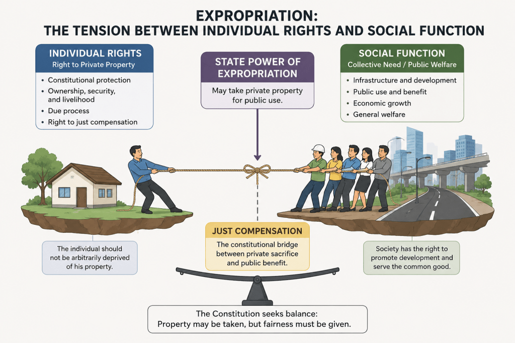
Expropriation is not a simple and ordinary appraisal assignment. It is a judicial proceeding involving property rights, public interest, legal procedures, and the constitutional requirement of just compensation. An appraiser appointed by the court, whether as Commissioner or member of a Board of Commissioners, carries a responsibility that extends beyond determining market value.
Over the years, I have developed a series of questions that I ask myself before accepting an expropriation assignment.
1. Am I a Disinterested Person?
The first document I request from the client is a copy of the Complaint.
Before discussing value, I want to know:
- Who are the parties?
- What property is involved?
- What is the nature of the taking?
- Do I have any relationship with the parties?
This allows me to determine whether there is any actual or perceived conflict of interest.
The Rules of Court require a Commissioner to be a disinterested and competent person. Independence is therefore not merely an ethical consideration—it is a legal requirement.
2. Am I Competent to Accept This Assignment?
The next question is equally important.
Do I possess the competence required by the Court for this particular case?
Expropriation requires more than valuation knowledge. An appraiser must understand the legal framework governing the proceeding.
Among the important laws and rules that should be familiar to an expropriation appraiser are:
- Rule 67 of the Rules of Court (Expropriation)
- Rule 32 of the Rules of Court (Commissioners)
- RA No. 8974 and its amendments
- RA No. 12001 RPVARA
- The ARROW Act and its Implementing Rules
- Comprehensive Agrarian Reform Law
- Local Government Code
- Relevant jurisprudence on just compensation and property rights
Understanding these laws allows the appraiser to appreciate the broader litigation process, the role of the parties, the duties of the commissioners, and the standards by which the court evaluates evidence.
3. Who Is the Expropriating Authority?
Another important question is:
Who is exercising the power of eminent domain?
Is it:
- A national government agency?
- A government-owned or controlled corporation?
- A local government unit?
- A utility company exercising delegated eminent domain powers?
- Another entity authorized by law?
The answer helps determine the applicable legal framework, the procedures involved, the source of funding, and the nature of the project.
For example, national government infrastructure projects may involve RA No. 8974, RA No. 12001, the ARROW Act, and related regulations. Local government expropriations may involve different statutory requirements under the Local Government Code. Utility companies and government corporations may likewise operate under special laws.
Before determining value, the appraiser must first understand who is taking the property and under what authority such taking is being exercised.
4. What Property Right Is Being Taken?
One of the most common mistakes is assuming that every expropriation involves the acquisition of full ownership.
Not all takings are the same.
The government may acquire:
- Fee simple ownership
- Right-of-way
- Easement
- Transmission line corridor
- Temporary construction easement
- Access rights
- Portions of improvements
Before value can be determined, the property right being acquired must first be identified.
You cannot value what you have not properly defined.
5. What is the Time of Taking?
One of the most important questions in any expropriation assignment is:
What is the legally recognized date of taking?
Many appraisers mistakenly assume that valuation is always based on the current value of the property or that the date of taking is uniform across all compulsory acquisitions. In reality, the applicable valuation date often depends on the governing law, the nature of the acquisition, and the circumstances of the case.
For example, infrastructure right-of-way acquisitions, traditional expropriation proceedings under Rule 67, and agrarian reform acquisitions may involve different legal frameworks and different approaches in determining the relevant date for valuation.
In agrarian reform cases, the issuance of a Notice of Coverage does not automatically constitute the date of taking. While it marks the commencement of the acquisition process, jurisprudence has recognized that the determination of the date of taking requires an examination of when the landowner was effectively deprived of ownership rights, possession, use, enjoyment, or economic benefits of the property, as contemplated by the governing agrarian laws.
Similarly, in infrastructure and right-of-way acquisitions, the legally relevant date may be influenced by statutory provisions governing possession, entry, deposits, negotiated acquisition, and expropriation proceedings.
The valuation date is not merely a procedural matter. It is often one of the most significant legal issues in the determination of just compensation. A difference of several years between the date of taking and the date of appraisal can substantially affect the value conclusion and the amount ultimately awarded by the court.
Before determining value, the appraiser must first determine the applicable law, identify the legally relevant date of taking, and understand the jurisprudence governing that acquisition.
The question is not:
“What is the property worth today?”
The more important question is:
“What was the property worth on the date recognized by law for purposes of determining just compensation?”
6. What Standard of Value Is Required?
Many appraisers immediately think in terms of market value.
However, the court is often concerned with just compensation.
The two concepts are related but not always identical.
An appraiser must understand:
- Market value
- Just compensation
- Consequential damages
- Consequential benefits
- Compensation for improvements
- Compensation for crops and other affected interests
Understanding the applicable legal standard is essential.
7. What Evidence Supports My Opinion?
The first question should not be:
“What comparables are available?”
The better question is:
“What evidence is available?”
Comparable sales are important, but they are only one form of evidence.
The appraiser must also examine:
- Property characteristics
- Property rights
- Legal conditions
- Planning evidence
- Economic evidence
- Market evidence
A valuation that relies solely on comparable sales may fail to capture the broader realities affecting value.
8. How will I personally inspect the Property?
No amount of documentation can replace actual inspection.
Titles, plans, and tax declarations provide information.
Site inspection provides understanding.
Actual inspection often reveals:
- Existing access
- Physical conditions
- Occupation
- Improvements
- Constraints
- Opportunities
Many critical valuation issues are discovered only in the field.
9. Can the Judge Understand My Report?
One of the purposes of a Commissioner’s Report is to assist the court.
A technically correct report that cannot be understood by the judge has failed in one of its essential functions.
The appraiser must be able to explain:
- The facts
- The evidence
- The reasoning
- The conclusions
in a clear and understandable manner.
10. Can I Defend My Opinion Under Oath?
Every valuation submitted to the court will be examined, questioned, and challenged.
Ask yourself:
- Are my comparables defensible?
- Are my adjustments supported?
- Is the highest and best use justified?
- Have I verified the title?
- Have I disclosed limitations and assumptions?
A report should be prepared with the expectation that it will be scrutinized by lawyers, judges, and other experts.
Before submitting any report, I ask myself one final question: If I am placed on the witness stand tomorrow, can I confidently explain every assumption, adjustment, conclusion, and recommendation contained in this report?
If the answer is no, more work is required.
The report is not yet ready.
Conclusion
Expropriation appraisal is not merely an exercise in determining value.
It is the process of assisting the court in determining just compensation for the taking of private property.
The appraiser’s role therefore extends beyond market analysis. It requires competence in property rights, valuation, evidence, legal procedure, and professional judgment.
In my experience, the most important question is not:
“Can I determine value?”
The more important question is:
“Can my valuation withstand the scrutiny of the court?”
That is where expropriation appraisal truly begins.