Augusto B. Agosto, EnP · World Town Planning Day, 8 November 2026
Every 8 November, planners around the world observe World Town Planning Day. The observance began in 1949 through the initiative of the Argentine planner Carlos María della Paolera, who wanted the public to see planning as something that shapes ordinary life rather than a specialist exercise carried out behind closed doors. Seventy-seven years later, that idea deserves renewed attention in the Philippines.
This year I am marking the day by circulating a short manifesto calling for a genuine people-centered organization of environmental planners and allied professions. This article explains why I believe such an organization is needed, what it should look like, and what it must avoid becoming.
The Stakes Have Risen
Planning decisions have always allocated land, infrastructure, and risk. What has changed is the pressure under which those allocations are now made. Conflicts abroad, disruptions in trade and energy supply, and concerns over food security now feed directly into the cost of land, housing, and public services at home. At the same time, rapid urbanization, recurring climate-related disasters, environmental degradation, and unequal access to land continue to strain local governments that were never fully equipped to manage them.
In every cities, recurring floods, chronic congestion, and contested land-use decisions show how quickly a planning shortcoming becomes a household cost. A zoning choice made today determines who will be exposed to the next flood, who will pay more for housing, and who will spend hours each day in traffic. These are not technical questions alone. They are questions of welfare and fairness, and the people who bear the consequences rarely have a seat at the table where the choices are made.
A Profession That Talks Mostly to Itself
Since the passage of the Environmental Planning Act of 2013 (Republic Act No. 10587), environmental planning has been a regulated profession with licensure, continuing professional development, and an organized professional community. These are real achievements. Regulation protects the public by setting standards of competence and ethics.
Yet professional organization carries a familiar risk. Over time, an association can become preoccupied with representation, credentials, positions, and recognition. Conferences multiply, plans are prepared and approved, and compliance is documented, while the question that matters most goes unasked: did the plan improve anyone’s life once it was implemented?
The same risk appears in how communities are treated. Too often, consultation takes place after a plan has already been drafted, when the real choices have been made and the public is invited only to react. That is consultation as formality. It satisfies a procedural requirement without giving affected people any real influence.
What a People-Centered Organization Would Do Differently
First, it would be interdisciplinary in fact, not only in rhetoric. Land-use decisions have economic, legal, engineering, ecological, and social consequences, and no single profession can see all of them. In my own work as an appraiser and court-appointed commissioner, I regularly see planning decisions return years later as valuation disputes in expropriation and right-of-way cases. The economist, the lawyer, the engineer, and the planner are often looking at the same parcel of land from different sides. An organization that brings them together from the start would produce better plans and fewer costly disputes.
Second, it would give communities a formal place in its work. Farmers, fisherfolk, workers, informal settlers, indigenous peoples, entrepreneurs, and property owners hold knowledge that no technical survey captures. A people-centered organization would create channels through which they participate in shaping plans, while preserving the standards and legal responsibilities that bind licensed professionals. Communities should not be consulted only after a plan is written. They should help write it.
Third, it would be independent. Planning involves competing claims from government agencies, investors, landowners, developers, and communities. Each deserves a hearing, but none should prevail by default over sound planning and the general welfare. An independent organization must be willing to support a policy when the evidence justifies it and to question it when it threatens sustainability, equity, efficiency, or the rule of law. It cannot serve as an extension of political authority, an instrument of private economic influence, or a platform for the ambitions of its officers.
Fourth, it would practice the governance it preaches. An organization that advocates transparency and accountability for government must apply the same standards to itself: accountable leadership, open decision-making, prudent finances, and room for genuine debate. No individual or faction should hold unquestioned authority over professional discourse, and competence should not be measured by titles or influence.
Judging Plans by What They Achieve
A recurring theme is that the measure of planning is its outcome. A comprehensive land use plan that is approved but not implemented, or implemented in ways that ignore its own hazard maps, has not protected anyone. The test of a plan is whether it leaves society better able to withstand shocks and sustain development.
This is ultimately an economic argument as much as an environmental one. Every peso spent on disaster recovery that sound land allocation could have avoided is a peso lost to schools, health care, and housing. Good planning anticipates risk and prevents avoidable losses. It does not wait to calculate the cost of recovery.
Anticipating the Objections
Some will ask whether the country needs another organization at all. The call is to build an open, interdisciplinary space where professional knowledge is tested against public need and where communities have a voice. Such a space complements existing institutions rather than competing with them.
Others will worry that opening an organization to non-professionals dilutes standards. It need not. Professional responsibility for technical work remains with those licensed to perform it. Participation and licensure are different things, and an organization can honor both.
An Invitation
World Town Planning Day is usually an occasion for celebration, and there is much in Philippine planning worth celebrating. But it should also be an occasion for honest reflection about whom our profession serves.
I invite environmental planners, urban planners, economists, engineers, architects, lawyers, appraisers, educators, researchers, and community leaders who share these concerns to join the conversation. We do not organize to protect a profession. We organize to ensure that our professions serve the people.
Why redevelopment should come before reclassification — is Cebu City running out of commercial land, or failing to maximize the economic potential of its existing business districts?
The question becomes particularly relevant when examining the Comprehensive Land Use Plan (CLUP) 2023–2032, which proposes a substantial expansion of land allocated for commercial purposes.
Based on the land-use figures examined in this study, Cebu City had approximately 983.16 hectares of existing commercial land in 2020. Under the proposed CLUP, the commercial allocation increases to approximately 2,038.63 hectares — an additional 1,055.47 hectares, equivalent to an increase of 107.35 percent.
The figures are striking, and they require careful interpretation. The 2020 figure describes existing land use; the proposed figure represents planned allocation. The difference doesn’t necessarily mean that 1,055 hectares of agricultural or undeveloped land will be converted into commercial establishments. Still, the magnitude of the proposed increase demands an economic explanation.
Where will the additional commercial demand originate? How much commercial floor space will Cebu City actually require? How much of that can be absorbed within existing business districts? And what are the infrastructure, environmental, and financial consequences of expanding commercial development into new locations? These aren’t peripheral questions — they’re fundamental to the economic justification of the land-use plan.
The Historical Creation of Cebu City’s Business Districts
Cebu City’s commercial development didn’t begin with modern business parks. Historically, the city’s economic geography developed around the port, waterfront, Colon Street, Carbon Market, and the surrounding downtown commercial districts. Maritime commerce, warehousing, wholesale distribution, retail activity, transportation, banking, and other commercial services concentrated within a relatively compact urban area, with the port moving goods and Colon, Carbon, and adjoining streets providing the markets, services, and distribution networks.
Cebu’s commercial geography then expanded through a series of major development initiatives:
Period
Commercial district or development
Development significance
Historical period
Cebu Waterfront and Port District
Maritime commerce, shipping, warehousing, wholesale trade, and logistics
Historical period
Colon–Carbon–Downtown
Traditional retail, banking, trading, and commercial services
1960s–1980s
North Reclamation Area
Expansion of port-related, warehousing, commercial, and urban land
1989–1994
Cebu Business Park
Redevelopment of a former golf course into a planned business district
1990s
North Reclamation commercial establishments
Expansion of major retail and commercial activity
Late 1990s–2000s
Cebu IT Park
Transformation of the former Lahug Airport into an employment and technology center
2000s onward
South Road Properties
Government-led reclamation creating new development land for mixed commercial and other uses
This history reveals something important: Cebu City’s major commercial centers were not created merely by assigning additional land to commercial zoning. They emerged through strategic location, infrastructure investment, land redevelopment, institutional decisions, private capital, and effective market demand working together.
Cebu Business Park was developed through the transformation of an existing urban property; Cebu IT Park emerged from the redevelopment of the former Lahug Airport. Both show how urban land can be reorganized toward higher-value economic activity without necessarily expanding the city’s physical footprint. South Road Properties took a different route — the creation of additional urban land through reclamation, backed by major public infrastructure investment. Each model carries different economic and environmental implications.
The Forgotten Economic Potential of Colon and Downtown Cebu
Colon Street and its surrounding commercial districts are among Cebu City’s most historically significant economic areas, even as much of the city’s contemporary development attention has shifted toward newer business centers. That shift raises a real planning issue: the relative decline of commercial activity in portions of downtown Cebu shouldn’t automatically be read as evidence that these areas have exhausted their development potential. If anything, the presence of older commercial buildings, underutilized properties, fragmented landownership, and aging infrastructure may point to redevelopment opportunity rather than terminal decline.
Colon already holds advantages that many proposed commercial expansion areas would need substantial investment to reproduce — established commercial activity, public transport connections, surrounding residential populations, existing roads, utility networks, and a recognizable urban identity. The challenge isn’t simply to preserve its historical character; it’s to restore its economic competitiveness while retaining its social and cultural significance.
A comprehensive downtown redevelopment strategy could include adaptive reuse of older buildings, rehabilitation of commercial structures, selective vertical redevelopment, improved pedestrian circulation, drainage modernization, public transport integration, and incentives for assembling fragmented land parcels. Heritage conservation and economic redevelopment need not pull against each other — with appropriate planning controls, heritage buildings can accommodate retail, hospitality, cultural, professional, educational, and other economically productive uses. Colon’s redevelopment should be examined as an economic development strategy, not merely as an urban beautification project.
The Waterfront and Port District: An Existing Economic Asset
The same reasoning applies to Cebu City’s waterfront, port district, and North Reclamation Area — decades of public and private investment in commercial and transport infrastructure. Historical planning records for the North Reclamation project identify approximately 169.3 hectares of reclaimed land, with planned allocations for retail commerce, wholesale trade, warehousing, offices, and related activities: roughly 14.67 hectares for arcaded retail commerce, 18.60 hectares for wholesale commerce, 3.67 hectares for mixed commercial uses, plus additional areas for offices and warehousing.
These are historical planned uses, not a current commercial inventory. But they establish that the waterfront and reclamation area were conceived from the start as significant economic development locations — which makes the live planning question whether these areas are being used at their economically and environmentally sustainable potential today.
Port modernization, logistics restructuring, redevelopment of obsolete commercial facilities, improved transport connections, and rehabilitation of underutilized waterfront properties could all generate additional economic activity. Operational port facilities, though, have to be distinguished from ordinary commercial land — port security, cargo handling, transport requirements, and the statutory responsibilities of port authorities impose constraints that any redevelopment strategy has to respect. The right approach integrates maritime economic functions with compatible commercial and urban activity, rather than simply replacing port uses with real estate development.
Commercial Land Is Not the Same as Commercial Capacity
A basic weakness in evaluating urban growth exclusively through land-area allocation is that land area doesn’t directly measure economic capacity. Commercial development capacity depends on permissible floor-area ratios, building heights, infrastructure availability, accessibility, development costs, land values, and market demand. A relatively small commercial district developed at higher intensity can accommodate more office, retail, hospitality, and service activity than a much larger low-density one.
Consider an illustrative scenario: if 50 hectares of land within an existing urban district could be redeveloped at an achievable floor-area ratio of 3.0, the resulting gross floor area would be approximately 1.5 million square meters. This is purely a theoretical illustration, not an estimate of Colon’s actual redevelopment capacity — existing floor area, roads, public spaces, noncommercial uses, development restrictions, and financial feasibility would all have to be factored in. But it shows why commercial land requirements shouldn’t be determined by hectares alone.
The relevant planning calculation is:
Additional commercial floor-space demand minus feasible unused capacity within existing commercial districts equals the residual requirement for additional commercial development land.
Without that assessment, it’s difficult to say whether the proposed expansion of commercial zoning is economically necessary at all.
The Economic Cost of Outward Commercial Expansion
Allocating additional land for commercial development isn’t costless. New commercial districts may require roads, drainage, water supply, sewerage, electricity, public transport services, and other infrastructure. Where development extends toward environmentally constrained areas, additional costs can arise from slope stabilization, flood mitigation, watershed protection, and other engineering or environmental measures — costs that aren’t always fully reflected in the private market price of land, and that may ultimately fall on local government, utility providers, surrounding communities, or the wider public.
From the standpoint of land economics, the decision to expand commercial land allocation should weigh the total social cost of development, not just the potential increase in private property values. That’s especially important in Cebu City, where redevelopment opportunity in established urban districts coexists with real pressure for development in upland and environmentally sensitive locations. The question isn’t whether outward development should be prohibited outright — it’s whether the economic benefits of expansion exceed the costs, measured against feasible redevelopment alternatives.
When Commercial Zoning Becomes an Instrument of Speculation
There’s another dimension worth examining: the relationship between commercial zoning and land speculation. A change from agricultural or low-intensity use to commercial zoning can raise the anticipated development potential of land, and because market participants price property partly on its expected future use, the prospect of commercial reclassification can show up in land prices before any actual development occurs. That’s the capitalization of anticipated development rights into land value.
This capitalization isn’t inherently improper — land markets routinely respond to changes in permitted uses, accessibility, infrastructure, and economic expectations. But where substantial commercial land is allocated without corresponding evidence of effective demand or feasible development, zoning may be creating speculative opportunity rather than responding to demonstrated economic need. Land can be acquired, held, or traded in anticipation of future price appreciation even when immediate commercial development is unlikely.
This is the same distinction between development opportunity and development capacity that ran through the first part of this series, applied here to commercial rather than residential or watershed land: zoning creates a legal opportunity to develop, but it doesn’t by itself supply the infrastructure, environmental suitability, financial feasibility, or market demand that makes development actually viable. The gap matters most where proposed commercial allocations sit in areas where transport accessibility, public utilities, environmental conditions, or actual commercial demand remain uncertain.
A defensible investigation here would examine historical land transactions, ownership changes, advertised and completed sale prices, building permits, actual construction, and infrastructure investment. The existence of speculative activity can’t be inferred from the commercial land increase alone — but the absence of a credible land-demand analysis would make the justification for that expansion a fair subject of further scrutiny.
What Earlier Planning Studies Tell Us
Cebu City’s commercial expansion deserves to be read in its historical context, and earlier planning studies reinforce that. The Metro Cebu Land Use and Transportation Study, begun in the late 1970s, recognized the importance of coordinating land development with transportation and metropolitan economic growth. JICA’s Roadmap Study for Sustainable Urban Development in Metro Cebu (2015) examined urban structure, existing land use, infrastructure, and development suitability. The World Bank’s Philippines Urbanization Review (2017) identified problems with outdated land-use planning and fragmented urban development.
These studies are important historical and institutional references. They don’t by themselves establish that the current CLUP is defective or that any particular commercial designation is unlawful — but they do reinforce the need to evaluate land allocation as part of a broader urban economic and environmental system. They also raise a legitimate question: how were their findings, development strategies, and spatial assessments actually incorporated into the current CLUP?
The Missing Comparison: Redevelopment Versus Expansion
Before Cebu City commits to a substantial increase in commercial land allocation, its planning framework should demonstrate that the redevelopment capacity of existing business districts has been evaluated. At a minimum, that assessment should cover:
Colon–Carbon–Downtown: potential for commercial rehabilitation, adaptive reuse, land assembly, urban renewal, and increased development intensity.
Waterfront–Port–North Reclamation: potential for port modernization, logistics redevelopment, commercial renewal, and improved integration with downtown.
Cebu Business Park and Cebu IT Park: remaining permissible floor area, redevelopment opportunities, and existing commercial capacity.
South Road Properties: undeveloped commercial parcels, committed projects, infrastructure capacity, and anticipated market absorption.
Other established commercial corridors: vacant and underutilized properties that may accommodate future growth.
That study should then compare the additional floor-space capacity of these locations against projected employment growth, retail demand, office demand, hospitality demand, and other commercial requirements — and evaluate infrastructure costs, development feasibility, transport accessibility, environmental effects, and potential displacement alongside it. Only after that analysis can the residual need for new commercial land be estimated with any real confidence.
Reconsidering Cebu City’s Commercial Land Allocation
The proposed increase from 983.16 hectares to 2,038.63 hectares shouldn’t be read as a simple comparison of two numbers. The existing figure represents actual land use; the proposed figure reflects future allocation. Some land already designated commercial may not yet be developed, and special economic zones and mixed-use districts may be treated differently across planning documents — a proper spatial analysis has to distinguish existing commercial activity, legally designated commercial land, unused commercial development rights, and newly proposed commercial areas from one another.
This distinction matters because an earlier Cebu City planning framework already contemplated substantial commercial allocations, so the current proposal may represent a continuation or reorganization of earlier planning directions rather than an entirely new expansion strategy. Even so, the central economic question remains unresolved:
Has Cebu City demonstrated that its established commercial districts cannot accommodate the projected increase in commercial activity before proposing substantially more land for commercial development?
If that answer isn’t supported by credible technical evidence, the commercial allocation deserves further examination.
Conclusion: Redevelop First, Expand Where Justified
Cebu City’s economic future shouldn’t be measured by the number of hectares it designates for commercial development. A more meaningful measure is how productively, efficiently, inclusively, and sustainably its urban land is actually used.
Colon and downtown Cebu represent the city’s historical commercial foundation. The waterfront and port district remain important economic assets. Cebu Business Park, Cebu IT Park, and SRP demonstrate three different approaches to commercial development — through redevelopment, planned estates, and reclamation. Together, these districts embody substantial accumulated investment in land, infrastructure, and urban economic activity, and their remaining development capacity should be carefully assessed before additional commercial expansion is justified.
The policy principle is straightforward:
Redevelop existing urban land where economically feasible, intensify established commercial centers where infrastructure permits, and expand commercial land only where demonstrated demand, accessibility, infrastructure capacity, and environmental suitability justify doing so.
This isn’t an argument against urbanization or commercial growth. It’s an argument for better economic allocation of land. Cebu City doesn’t necessarily need to create more commercial land to create more economic opportunity — it may first need to recover the development potential of the urban land it already has. The test of a comprehensive land-use plan, in the end, isn’t how much land it opens for development, but whether its allocations produce genuine economic value while protecting the environmental systems, public resources, and communities the city’s future depends on.
references
World Bank. (2017). Philippines Urbanization Review: Fostering Competitive, Sustainable and Inclusive Cities.World Bank report.
Japan International Cooperation Agency. (2015). Roadmap Study for Sustainable Urban Development in Metro Cebu.JICA report.
Cebu City Government. Comprehensive Land Use Plan 2023–2032, existing and proposed land-use allocation tables.
Cebu City Government. Ordinance No. 1656, 1996 Revised Zoning Ordinance, and Ordinance No. 2784, 2025 Revised Zoning Ordinance.
Editorial note: The comparative hectare figures are drawn from the working CLUP figures previously discussed and should be checked against the authenticated official tables before publication. The precise redevelopment boundaries and unused development capacity of Colon–Carbon–Downtown and Waterfront–Port–North Reclamation have not yet been quantified.
The recent warning raised by Architect Yumi Espina regarding the mounting urbanization pressures confronting Metro Cebu deserves serious consideration. His observations on climate vulnerability, infrastructure limitations, environmental degradation, and the need for metropolitan coordination highlight the increasingly complex challenges facing Cebu’s urban development.
I’d extend the discussion beyond the conventional argument that rapid urbanization is threatening the survival and livability of Metro Cebu.
Urbanization, by itself, is not the problem. The more fundamental issue is how land is allocated, developed, and regulated under competing economic, social, and environmental demands.
Urbanization is an economic process. It reflects the concentration of population, employment, capital, infrastructure, and productive activities. When properly managed, it generates economies of scale, improves access to services, and creates opportunities for growth. The difficulty arises when the expansion of urban development exceeds the capacity of infrastructure and natural systems to support it.
Consider two residential developments in Metro Cebu. The first sits within an established urban area with adequate drainage, transportation access, water supply, and public services. The second occupies sloping upland terrain, where extensive land grading, vegetation clearing, and construction may alter natural drainage patterns. Both contribute to economic activity and accommodate housing demand. Their environmental consequences, however, can differ considerably — the second may increase surface runoff and sedimentation, particularly where downstream drainage systems are already inadequate. The extent of these effects depends on the site’s physical conditions, development design, and mitigation measures, and has to be established through proper technical assessment.
This illustrates a basic principle in land economics: a development may be financially profitable to its owner while imposing environmental and social costs on surrounding communities. These are negative externalities — they arise when the full consequences of a private economic activity are not borne by the party undertaking it.
Architect Espina’s warning about Metro Cebu’s environmental pressures is particularly significant because he previously headed the Cebu City Planning and Development Office and helped lead the preparation and advancement of the CLUP for 2023–2032.
This places him in a position to contribute meaningfully to the continuing evaluation of the plan.
The CLUP identifies flood control, environmental conservation, and sustainable urban development among its planning objectives. These are important commitments. However, identifying such objectives does not, by itself, establish that the resulting land-use allocations, zoning classifications, and development controls are sufficient.
The question is whether the plan’s provisions can effectively manage the environmental risks associated with future development. For example, how are upland development intensities determined? What environmental thresholds govern land conversion? How are downstream flood impacts considered? Are infrastructure limitations adequately incorporated into development decisions?
These are substantive planning questions that deserve technical examination.
Given Espina’s recent warnings, I believe it would be constructive for him to support an independent and comprehensive review of the CLUP, including appropriate amendments where technical evidence establishes deficiencies.
Such a position would reinforce, rather than diminish, his contribution to Cebu City’s planning process.
Upland Development and the Watershed Problem
The work of Dr. Ramon C. Sevilla on Cebu’s urban development and watershed governance offers an important perspective here. It draws attention to the relationship between upland development, watershed conditions, drainage infrastructure, and the governance challenges confronting Cebu City.
The significance of upland development extends beyond the boundaries of a single property. Watersheds operate as interconnected systems — changes in land cover, soil permeability, slope conditions, and drainage in one location can affect water movement elsewhere in the catchment. A development proposal, then, can’t be evaluated solely on its economic feasibility or its compliance with a given zoning classification. It also has to be examined for its cumulative effect on the watershed and on the communities that depend on it. This matters especially in Metro Cebu, where upland and downstream communities are connected through river systems that cross administrative boundaries.
Flooding, in other words, shouldn’t be understood exclusively as an engineering problem solved by larger canals, better drainage, or flood-control structures. It’s also a land-use allocation problem. Engineering interventions remain necessary, but their effectiveness is constrained if land development keeps altering runoff conditions or occupying areas essential to natural drainage and floodwater storage.
Why Development Control Matters
This brings us to a fundamental function of urban and environmental planning: development control.
Land-use planning determines how land is allocated among competing uses. Development control regulates how those opportunities may actually be exercised. A property classified for residential development shouldn’t automatically be treated as suitable for unrestricted construction. Depending on site characteristics, development controls may limit building density, land coverage, slope disturbance, vegetation removal, impervious surfaces, and stormwater discharge — and may require drainage facilities, retention systems, and environmental buffers. The goal isn’t necessarily to prohibit development, but to keep its intensity and physical characteristics consistent with the environmental and infrastructural capacity of the site.
Land-use planning allocates development opportunities; development control ensures those opportunities are exercised within acceptable environmental, economic, and social limits.
From the standpoint of land economics, development control also addresses market failure. A developer evaluates a project based on land acquisition costs, construction expenses, anticipated revenue, and financial return. That private feasibility calculation, however, doesn’t necessarily capture increased downstream flood exposure, added infrastructure burden, ecological degradation, or other costs the public ends up bearing. Effective development control is how those wider consequences get accounted for, through standards, conditions, and regulatory requirements.
The CLUP as an Economic Allocation Instrument
This reinforces a position I’ve held for some time: Cebu City’s Comprehensive Land Use Plan needs to be evaluated as more than an exercise in assigning zoning classifications. A CLUP is fundamentally an instrument for allocating scarce land resources among competing economic, environmental, and social uses — it determines not only where development may occur, but how development opportunities are distributed across the city.
This is where the distinction between development capacity and development opportunity becomes essential. Development capacity refers to the legal, physical, environmental, and infrastructural conditions that determine whether land can actually accommodate a particular use and intensity of development. Development opportunity refers to its economic attractiveness — financial feasibility, effective market demand, anticipated returns. The two are related but not interchangeable: a property may command a high market value and attract substantial investment without possessing the environmental capacity to accommodate intensive development. Land that performs an important ecological function, conversely, may carry a low observable market price despite generating real benefits for surrounding communities.
This is precisely why market demand and private profitability can’t serve as the sole criteria for land-use decisions. A sound CLUP has to reconcile economic opportunity with environmental limitations, infrastructure requirements, and broader public welfare.
Natural Capital and the Economic Value of Watersheds
A further weakness in conventional land-use planning is treating undeveloped land primarily as a future construction site. Forests, rivers, wetlands, floodplains, and other natural systems perform economically valuable functions — watersheds regulate runoff, retain water, support groundwater recharge, reduce erosion, and provide ecological services that benefit urban and rural communities alike. These functions constitute natural capital, and their value doesn’t always show up in ordinary real estate transactions even though their loss generates real economic costs.
This is where the Philippine Ecosystem and Natural Capital Accounting System (PENCAS) becomes directly relevant. PENCAS provides a framework for measuring the stock and flow of ecosystem services — water regulation, carbon storage, erosion control, and similar functions — in terms that can sit alongside conventional economic accounts, rather than treating them as externalities invisible to planning and investment decisions. Folded into a CLUP, this kind of accounting gives planners a basis for weighing a parcel’s ecosystem contribution against its development value, instead of defaulting to whichever use generates the higher observable price.
This doesn’t mean all environmentally sensitive land must remain undeveloped. It means land-use decisions need a more rigorous accounting of the trade-offs involved. The highest financial return from a property is not necessarily the highest economic benefit to society — and a planning framework that can’t see natural capital will systematically undervalue it.
Beyond Cebu City: The Regional Dimension
The emphasis on metropolitan coordination matters because urbanization doesn’t stop at political boundaries. Metro Cebu functions as an interconnected economic and environmental region — its labor markets, housing demand, transportation networks, infrastructure systems, watersheds, and investment activity extend across several local government units, and in fact beyond Metro Cebu into the wider Cebu region. A development decision made in one locality can affect traffic, infrastructure demand, water resources, and environmental conditions in a neighboring one.
But regional coordination shouldn’t be reduced to standing up another administrative body. The more fundamental question is whether the instruments and institutions that already exist — comprehensive land-use plans, zoning ordinances, environmental assessments, watershed management programs, development permitting systems — are being coordinated and enforced effectively. Metro Cebu doesn’t suffer primarily from an absence of planning mechanisms; it suffers from inconsistent technical rigor, weak enforcement, and limited accountability across the mechanisms it already has. Adding a new coordinating body without resolving those underlying weaknesses risks adding another layer of process rather than more effective outcomes. Regional planning should integrate the instruments already in place, while recognizing that the economic and environmental systems they’re meant to govern don’t respect jurisdictional lines.
Rethinking Cebu’s Development Model
Metro Cebu’s urbanization challenges call for more than additional infrastructure, new planning institutions, or blanket restrictions on development. They call for a clearer understanding of the economic forces driving land conversion and urban expansion, and of the environmental limits those forces operate within.
The relevant question isn’t whether Cebu should continue developing — economic growth, housing production, and infrastructure expansion remain necessary. The question is where development should occur, what intensity of use the site can support, what environmental services may be affected, and who ultimately bears the costs. These are the questions that should guide the preparation and implementation of comprehensive land-use plans and development controls, and they require stronger integration of land economics, watershed science, natural capital accounting, and environmental planning.
Urbanization is an economic reality. Sustainable urbanization is a matter of deliberate land allocation, effective development control, and environmental accountability. The livability and long-term economic productivity of Metro Cebu will depend not on how much development it accommodates, but on whether its scarce land and natural resources are allocated and managed in a way that balances private investment, public welfare, and ecological sustainability.
By Augusto B. Agosto, JD, EnP, Economist, Consultant
When most people think of property valuation, they picture land, buildings, machinery, and infrastructure—tangible assets that can be easily inspected, measured, and compared in the marketplace. For water-dependent enterprises, however, a more fundamental question often arises: What is the value of the resource that makes the entire enterprise possible?
A water treatment plant without water has little utility; pipelines without water cannot generate revenue; and reservoirs without water are merely empty storage facilities. Yet, traditional valuation approaches often focus heavily on physical assets while giving limited attention to the underlying resource and the legal rights that govern access to it.
Recent professional engagements involving bulk water supply systems, utility infrastructure, and water-related enterprises prompted me to revisit a question that sits precisely at the intersection of law, economics, environmental planning, and valuation: Can the value of a water enterprise be fully explained by land and physical improvements alone? The answer is considerably more complex than conventional appraisal practice suggests.
Who Owns the Water?
The starting point of any discussion on water rights in the Philippines is the Regalian Doctrine. Under Article XII, Section 2 of the Constitution, all natural resources—including waters—belong to the State. The Water Code of the Philippines (Presidential Decree No. 1067) further reinforces this by declaring that private entities may acquire only the right to appropriate and utilize water, subject to strict state regulation.
This distinction is critical for valuation professionals: private entities generally do not own the water itself. Instead, they acquire the legal authority to access, extract, treat, distribute, and utilize water for beneficial purposes. While a water permit is merely an administrative authorization from a legal perspective, from an economic perspective, that authorization represents a monumental source of value.
Water Rights as Economic Assets
Economics teaches us that value arises from scarcity. Although the Philippines is traditionally viewed as an island nation rich in water resources, many regions face acute water stress driven by population growth, rapid urbanization, watershed degradation, groundwater depletion, and climate-induced seasonal variability. As access to reliable water becomes premium, the economic significance of water rights increases proportionally.
Water rights act as economic catalysts by providing:
Access to a Scarce Resource: Guaranteed entry into a restricted natural market.
Security of Supply & Legal Certainty: Risk mitigation against operational disruptions and litigation.
Priority of Use & Investment Opportunities: The baseline confidence required to deploy heavy capital for infrastructure development.
In effect, water rights serve as the operational bridge that converts unpriced natural resources into productive, revenue-generating economic assets.
Lessons from Practice: Beyond Tangible Assets
Several recent valuation assignments involving watershed-based bulk water supply systems and utility infrastructure projects forced a departure from standard real estate appraisal. These engagements required an evaluation that looked beyond physical infrastructure to assess raw water sources, regulatory authorizations, off-take contractual arrangements, and long-term hydrological sustainability.
One particular assignment involving a watershed-based bulk water supply system raised several non-traditional questions:
What precise portion of enterprise value is truly attributable to land versus physical improvements?
How should the raw, productive capacity of the surrounding watershed be quantified?
What is the isolated economic value of the right to abstract and distribute water?
How does the long-term reliability of the water source impact overall enterprise risk and value?
To what extent do administrative permits and contractual off-take agreements contribute to the ongoing economic viability of the operation?
Answering these questions required moving past conventional property appraisal and venturing into resource economics, institutional rights, environmental planning, and natural capital accounting. The valuation ultimately demonstrated that the economic performance of the enterprise could not be explained solely by its tangible assets. A massive portion of its utility and income-generating capacity was inherently tied to the underlying water resource and the institutional frameworks safeguarding access to it.
Two Paths to Water Production
Observation of water enterprises in Cebu reveals an interesting operational dichotomy. Different enterprises produce marketable water through completely different asset profiles:
Production Typology
Resource Reliance
Primary Value Driver
Natural Capital-Dependent
Watersheds, springs, and deep groundwater systems.
High reliance on natural replenishment and ecological health.
Technology-Dependent
Desalination plants and advanced treatment systems converting seawater or brackish water.
High reliance on produced capital, energy inputs, and technological investments.
While both typologies generate revenue by delivering the same end product, their underlying asset structures differ fundamentally. One depends heavily on natural ecosystems; the other depends on engineered physical infrastructure. Yet, both share the same economic reality: without access to the baseline water resource (whether raw fresh water or raw seawater), neither infrastructure nor technology can generate revenue.
Natural Capital and Water Resources
The emerging field of natural capital accounting provides a precise framework for modernizing valuation practice. Natural capital refers to natural assets capable of generating flow-of-resource economic benefits. In this context, it encompasses:
Watersheds, aquifers, and natural springs.
Rivers, recharge areas, and critical forest ecosystems that regulate hydrological cycles.
Without healthy watersheds and functioning hydrological systems, physical water supply infrastructure loses its utility. Consequently, the comprehensive valuation of water enterprises demands that we look upstream at the sustainability and ecological health of the resource provider.
Beyond Valuation: Understanding How Water Creates Economic Value
The appraisal of water-dependent enterprises often begins as a valuation exercise. However, the analysis quickly extends beyond traditional questions of market value and into a broader examination of how value is created.
Water enterprises derive their economic significance not merely from land, infrastructure, or equipment, but from the interaction of natural resources, institutions, and markets. Watersheds generate water resources. Legal and regulatory systems allocate access through water rights and permits. Infrastructure transforms the resource into a usable product. Markets create demand. Together, these elements produce economic value.
Viewed from this perspective, water rights valuation is not simply an appraisal problem. It is fundamentally an economic inquiry into how natural capital is transformed into productive capital through institutional arrangements and investment.
The valuation question therefore becomes a gateway to a broader understanding of resource economics, natural capital, and economic development.
Recent developments—including the enactment of the Philippine Ecosystem and Natural Capital Accounting System (PENCAS), the Philippine Statistics Authority’s Water Accounts, and ongoing national water resource assessments—reflect a growing recognition that natural resources are not merely environmental assets but fundamental contributors to economic development and national wealth.
These initiatives have significantly advanced the measurement of water resources, ecosystem services, and natural capital. However, an important gap remains. Much of the existing literature focuses on water availability, water use, allocation, pricing, and conservation. Far less attention has been devoted to understanding how water resources create economic value and how institutional arrangements governing access to those resources influence investment, enterprise development, and wealth creation.
In particular, limited research has examined the role of water rights as institutional mechanisms that transform water resources into productive economic assets. The interaction between natural capital, legal entitlements, infrastructure investment, and economic production remains largely unexplored in the Philippine context. Understanding this relationship is increasingly important as water scarcity, climate risks, and competing resource demands place greater emphasis on the economic significance of water resources.
These questions form the foundation of the author’s ongoing research, which seeks to examine how scarcity, institutions, and water rights interact to create economic value within water-dependent enterprises and, more broadly, within the Philippine economy.
Conclusion
The discussion on water rights ultimately leads to a broader question than valuation itself. While appraisal seeks to measure value, economics seeks to understand how value is created. In the case of water-dependent enterprises, the answer extends beyond land, buildings, treatment facilities, and infrastructure.
The experience of examining bulk water systems suggests that economic value originates from the interaction of natural capital, institutions, and investment. Watersheds, aquifers, springs, and other water resources provide the physical foundation. The State, through the Regalian Doctrine and the Water Code, establishes the institutional framework governing access and allocation. Water rights and permits create certainty, enabling investment in infrastructure, treatment systems, and distribution networks that transform natural resources into economic output.
Viewed from this perspective, water rights are more than regulatory instruments. They serve as institutional mechanisms that connect natural capital to economic production. Understanding their role requires moving beyond traditional discussions of water use and toward a deeper examination of how water resources contribute to enterprise value, regional development, and national wealth.
Recent initiatives such as PENCAS, the PSA Water Accounts, and national water resource assessments signal a growing recognition of the economic importance of natural assets. Yet important questions remain. How do watersheds create economic value? How do institutions influence the allocation of scarce water resources? How do water rights support investment, productivity, and long-term development? These questions remain largely unexplored within Philippine literature and present opportunities for future research.
The inquiry that began as a valuation problem has therefore evolved into a broader economic question: how does a water resource become economic value? Exploring that question may not only improve valuation practice but also contribute to a deeper understanding of water governance, natural capital, and sustainable development in the Philippines. As water scarcity and climate-related challenges become increasingly significant, the ability to understand and account for the value created by water resources may prove essential to both economic policy and resource management in the decades ahead.
When investors discuss opportunities in Eastern Visayas, attention often gravitates toward Tacloban City, Leyte, and Samar. Yet beyond the region’s established centers lies a province quietly positioning itself for future growth—Southern Leyte.
Traditionally viewed as an agricultural province, Southern Leyte is increasingly emerging as a strategic growth corridor driven by transportation connectivity, tourism development, public infrastructure investments, and its unique position as the gateway between the Visayas and Mindanao.
While it may not yet command the same level of investment attention as larger provinces, many of the ingredients necessary for long-term economic expansion are already in place.
Strategic Location: The Province’s Strongest Asset
Geography often determines economic destiny.
Southern Leyte occupies a critical location at the southern end of Leyte Island, serving as the principal land and sea connection between Eastern Visayas and Northeastern Mindanao. The Liloan–Surigao route is one of the busiest inter-island transport links in the country, facilitating the movement of passengers, agricultural products, consumer goods, and commercial cargo.
This strategic position provides Southern Leyte with a natural competitive advantage in logistics, transportation, warehousing, and trade-related activities. As national infrastructure programs continue to improve roads, ports, and digital connectivity, the province stands to benefit from increased regional integration and economic mobility.
A Multi-Centered Provincial Economy
Unlike provinces dominated by a single urban center, Southern Leyte is developing through multiple growth nodes.
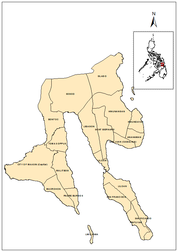
As the provincial capital, Maasin City functions as the center of government, education, healthcare, finance, and commerce. It serves as the primary urban market for the province and remains the focal point for public and private investments.
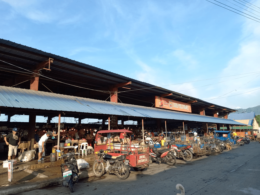
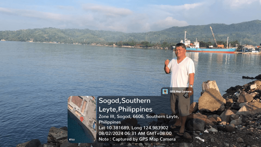
Sogod, the province’s only first-class municipality, has become an important commercial and transportation hub. Located along the Sogod Bay area, it serves as a crossroads connecting various municipalities and facilitating regional trade.
Hinunangan and neighboring municipalities provide agricultural production, fisheries resources, and growing commercial activity that contribute significantly to the provincial economy.
Together, these centers create a more resilient economic structure by distributing opportunities across the province rather than concentrating development in a single location.
Competitive Advantage and Economic Driver
While agriculture is often viewed as a traditional sector, it continues to provide Southern Leyte with a strong economic foundation.
The province’s major products include:
Coconut
Rice
Abaca
Fisheries products
Fruits and vegetables
Among these, abaca deserves special attention. As global industries increasingly seek sustainable and natural fibers, abaca presents opportunities for value-added processing, manufacturing, and export-oriented enterprises.
The challenge moving forward is not simply increasing production but strengthening agricultural value chains through processing facilities, logistics systems, market access, and technology adoption.
Southern Leyte possesses one of the most underappreciated tourism portfolios in the country.
Its attractions include:
Sogod Bay’s marine ecosystems
Whale shark encounters
Diving destinations
Limasawa Island, recognized as the site of the first recorded Easter Mass in the Philippines
Waterfalls, caves, and mountain landscapes
Coastal ecotourism destinations
Unlike highly urbanized tourism centers that face congestion and environmental pressures, Southern Leyte still enjoys the advantage of relatively intact natural resources.
This creates opportunities for sustainable tourism investments, including:
Eco-resorts
Dive tourism facilities
Adventure tourism
Community-based tourism enterprises
Heritage tourism development
As global tourism trends increasingly favor authentic and environmentally responsible experiences, Southern Leyte is well-positioned to compete.
Compared with highly urbanized markets, land values in many parts of Southern Leyte remain relatively affordable, creating opportunities for long-term investors willing to take a strategic view of future growth.
The province’s demographic expansion, infrastructure improvements, and economic diversification suggest that urban land demand is likely to increase over time.
Infrastructure as a Growth Catalyst
Infrastructure development continues to transform the province’s economic landscape.
Key assets include:
Pan-Philippine Highway connectivity
Maasin Port
Liloan Port
Roll-on/Roll-off ferry facilities
Expanding telecommunications infrastructure
Ongoing road improvement projects
These investments reduce transportation costs, improve market accessibility, and increase the attractiveness of the province for private investment.
Infrastructure not only supports economic activity—it also shapes future land values and development patterns.
Southern Leyte may not yet be considered a major investment destination, but many indicators suggest that its trajectory is changing.
Its strategic location, agricultural strengths, tourism assets, growing infrastructure network, and relatively affordable land base provide a foundation for long-term economic development.
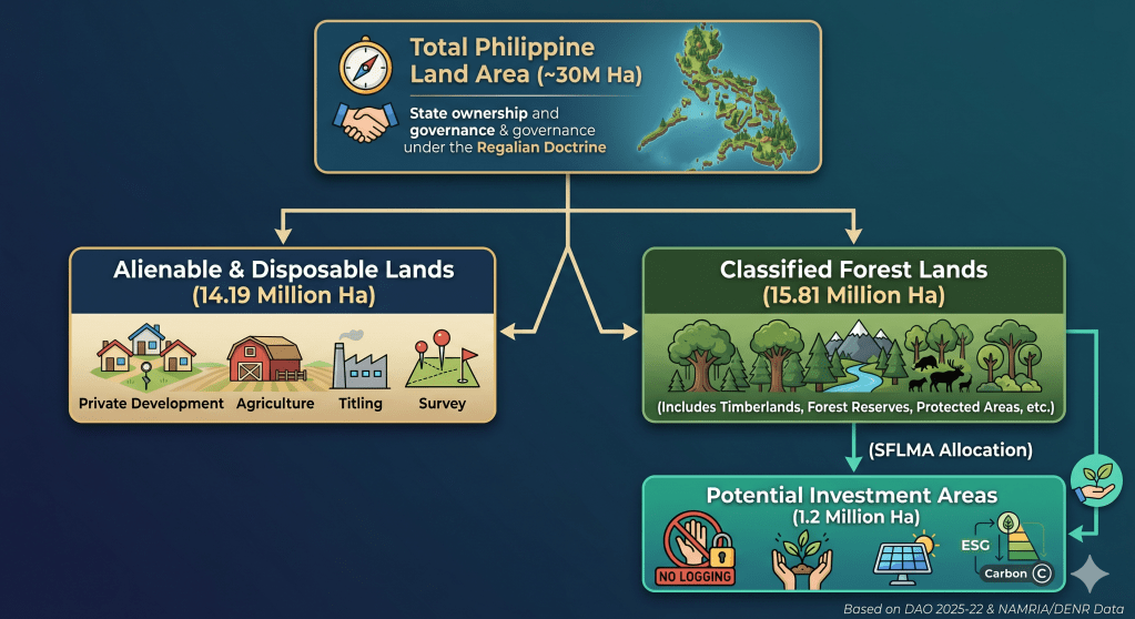
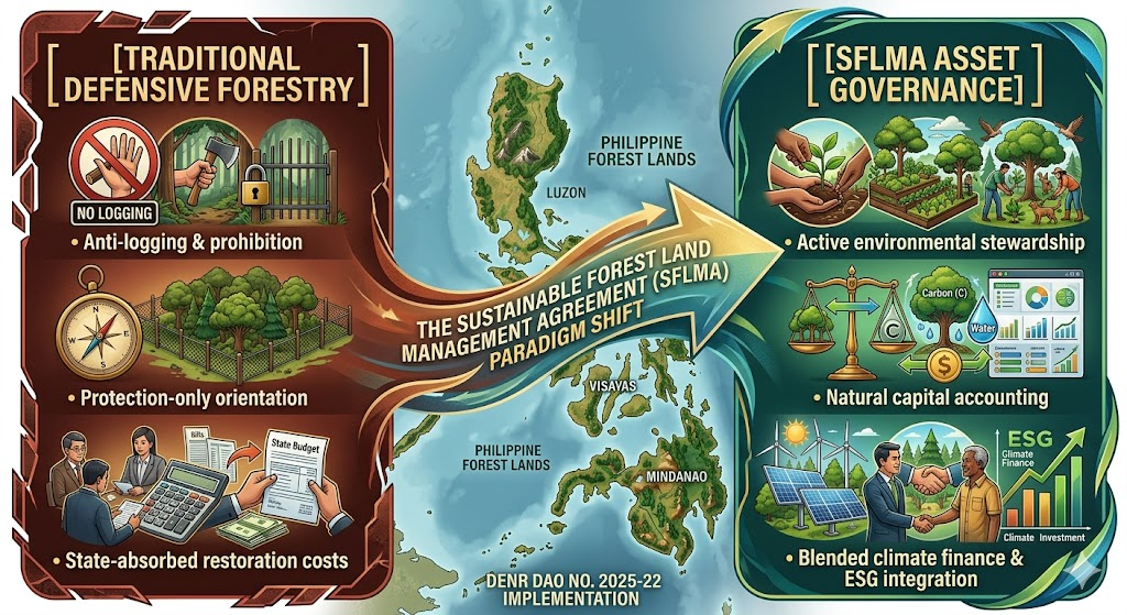
The implementation of the Sustainable Forest Land Management Agreement (SFLMA) under DENR Administrative Order No. 2025-22 marks a transformative shift from traditional, defensive forestry toward active environmental asset governance. This reform takes place against a complex legal backdrop where approximately 15.81 million hectares—over half of the Philippines’ total 30-million-hectare landmass—remain classified as public forest lands under the constitutional mandate of the Regalian Doctrine.
Historically, this system has suffered from institutional inertia, leaving official land boundaries largely unchanged since 2006 and creating a severe mismatch between legal designations and actual land use on the ground. However, the rise of the modern carbon economy has fundamentally reframed these spaces. Rather than treating forests merely as passive timber reserves or off-limits ecological zones, the SFLMA framework targets 1.2 million hectares of degraded public land—distributed across roughly 1,700 mapped parcels—to serve as climate infrastructure, carbon reservoirs, and natural capital assets.
Ultimately, this initiative places Philippine land governance at a critical intersection. The central challenge moving forward is balancing market-driven climate investments and carbon governance with the enduring constitutional principles of stewardship, social justice, and intergenerational responsibility.
II. The Carbon Economy and Legal Consolidation
One of the most consequential dimensions of the SFLMA is its architectural role in the emerging carbon economy. As international compliance and voluntary carbon markets mature, the framework provides the administrative and tenurial foundation required to host land-based carbon projects, verify forest carbon sequestration, and generate tradable carbon credits.
By offering long-term tenurial security, the SFLMA lowers the political and regulatory risk for institutional investors looking to fund nature-based solutions (NbS). Reforestation projects under this framework are uniquely positioned to serve as high-quality carbon sinks capable of issuing verified offsets for both domestic and international transfer.
Furthermore, this framework serves a critical state interest in regulatory streamlining. The SFLMA replaces and consolidates older, fragmented forest tenure systems, officially retiring:
Select commercial components of Community-Based Forest Management Agreements (CBFMA)
By collapsing these disparate instruments into a single governance mechanism, the DENR aims to eliminate conflicting land-use mandates, minimize institutional red tape, and lower transaction costs for clean-energy and conservation proponents. As the DENR noted during its rollout, the framework is explicitly designed to simultaneously generate rural employment, stimulate local economies, and boost the national gross domestic product (GDP) through sustainable forest enterprises.
III. Operationalizing SFLMA through the PENCAS Act
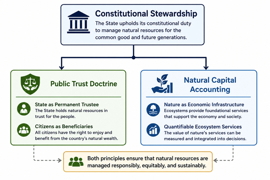
To properly realize its potential, the SFLMA framework must be linked directly to Republic Act No. 11995, otherwise known as the Philippine Ecosystem and Natural Capital Accounting System (PENCAS) Act. Passed to institutionalize the internationally accepted System of Environmental-Economic Accounting (SEEA), PENCAS provides the statutory framework that turns the theory of “environmental asset governance” into measurable fiscal and physical data.
While the SFLMA identifies 1.2 million hectares of Potential Investment Areas (PIAs) for carbon sequestration and ecosystem services, establishing their baseline value without a standardized legal methodology invites speculation. The PENCAS Act solves this challenge by mandating the collection and compilation of official statistics on the depletion, degradation, and restoration of natural capital.
Asset Accounts: Under PENCAS, the state must maintain strict physical and monetary accounts of timber and land assets, which directly inform SFLMA baseline data. This guarantees that carbon sequestration projects calculate genuine additionality rather than relying on unverified corporate metrics.
Quantifying Ecosystem Services: PENCAS legalizes the valuation of “regulating services”—such as carbon storage, water filtration, and flood protection—giving SFLMA proponents a government-sanctioned data framework to back up ESG investments and carbon-credit accounting.
2. Macroeconomic Integration vs. Project-Level Finance
Under R.A. 11995, natural capital statistics are integrated directly into the country’s macroeconomic indicators, meaning major environmental accounts are co-released with traditional economic indicators like GDP. This creates a dual-layered governance system: PENCAS operates at the macro-level to track nature’s aggregated wealth, while the SFLMA operates at the micro-tenurial level. The SFLMA serves as the contractual vehicle allowing private and community actors to manage specific plots of land using the uniform accounting standards established under PENCAS.
3. Verification and Safeguards Against Greenwashing
One of the primary critiques of the SFLMA is the high risk of greenwashing and corporate regulatory capture. The PENCAS Act introduces a critical check on this through its institutionalized accounting metrics. If an SFLMA concessionaire causes ecosystem degradation or implements biodiversity-poor monoculture plantations under the guise of carbon offsets, the localized reduction in ecosystem asset accounts provides public interest litigants with actionable, government-backed data to support petitions for environmental remedies, such as a Writ of Kalikasan.
IV. Constitutional Boundaries: The Public Trust Intersection
Despite its market-oriented mechanics, the SFLMA operates within rigid constitutional boundaries. Under Section 2, Article XII of the 1987 Philippine Constitution, all lands of the public domain and natural resources belong to the State under the Regalian Doctrine (Jura Regalia). Because public forest lands are inalienable, the SFLMA does not transfer ownership. Instead, it grants restricted stewardship and management rights, explicitly conditioned upon the continuous fulfillment of environmental obligations.
This arrangement operationalizes the constitutional philosophy that property bears a social function, meaning the right to utilize natural resources is inherently subordinated to the welfare of the common good. Consequently, the SFLMA sits at a complex legal intersection:
Under the Public Trust Doctrine, the State serves as the perpetual trustee of the nation’s natural wealth, while private and community actors function as temporary, fiduciary stewards. Every SFLMA project must therefore operate within legally defined ecological limits, ensuring that the exploitation of the asset does not impair the underlying public trust.
V. Systemic Risks, Drawbacks, and Structural Critiques
While structurally ambitious, the SFLMA framework exhibits several vulnerabilities, regulatory gaps, and socio-ecological risks that require rigorous mitigation.
1. The Commercialization of Ecospace and Greenwashing
By treating forests as natural capital, there is an immediate risk that environmental governance becomes subordinated to market incentives. If forests are valued primarily for their carbon credit yields and commercial ESG returns, biodiversity and deep ecological integrity may take a backseat.
This commercial focus invites structural greenwashing. Without robust, third-party verification protocols and data-driven carbon audit registries, corporate actors might exploit SFLMA concessions as cheap corporate branding vehicles. Weak state oversight could lead to speculative carbon banking, double-counting of offsets, and the generation of low-integrity carbon credits that fail to achieve genuine additionality.
2. Corporate Concession Dominance and Elite Capture
The framework permits large-scale corporate participation, allowing single entities to hold management rights over extensive tracts of land—in some instances up to 40,000 hectares. This high ceiling raises significant concerns regarding elite capture and land concentration. If large conglomerates dominate the competitive allocation of Potential Investment Areas (PIAs), smaller cooperatives, local civil society organizations, and marginalized upland communities may be priced out of the environmental asset market entirely.
3. Overlaps with Ancestral Domains and IP Exploitation
Spatial mapping data from the DENR indicates a critical geographic tension: approximately 85% of identified SFLMA parcels partially overlap with roughly 15% of ancestral domains occupied by Indigenous Cultural Communities (ICCs) and Indigenous Peoples (IPs).
While the law mandates compliance with the Free and Prior Informed Consent (FPIC) process under the Indigenous Peoples’ Rights Act (IPRA), there is a structural risk that this participation becomes merely transactional or symbolic. If indigenous communities lack equal bargaining power or sophisticated legal representation, they may find themselves excluded from meaningful benefit-sharing mechanisms and long-term project governance.
4. Ecological Conversion and Monoculture Risks
From an ecological standpoint, carbon-sequestration math often favors fast-growing, non-native commercial species over complex, slow-growing native silviculture. Policy research from the University of the Philippines warns that if regulatory safeguards are weak, the SFLMA could inadvertently incentivize the conversion of remaining natural secondary forests into simplified agroforestry or monoculture plantation systems, compromising local biodiversity and watershed resilience in the name of carbon maximization.
5. Regulatory Capture and Institutional Capacity Gaps
Simultaneously managing and auditing more than one million hectares of geographically dispersed forest lands demands an unprecedented level of technical, technological, and regulatory oversight. The DENR currently faces significant budgetary, staffing, and technological constraints. Without advanced remote sensing, real-time drone monitoring, and corruption-resistant auditing platforms, the SFLMA framework remains vulnerable to regulatory capture, illicit land conversions, and enforcement failures on the ground.
VI. Conclusion: Anchoring the Future Framework
The SFLMA brings a foundational tension in modern environmental law to the forefront: Should nature be governed primarily as an inviolable public trust, or as a quantifiable economic asset?
The doctrinal significance of DAO No. 2025-22 lies in its attempt to merge these two paradigms. It demonstrates that the Philippines is actively transitioning from a legacy of reactive environmental regulation to a proactive strategy of environmental asset governance.
The policy challenge moving forward is not whether the Philippines should participate in global climate finance or build domestic carbon markets; rather, it is whether these market mechanisms can remain firmly anchored to constitutional stewardship, social justice, and the principle of intergenerational responsibility (Oposa v. Factoran).
The ultimate success of Philippine carbon governance will depend on the state’s ability to develop a comprehensive legal framework that balances private economic utilization with robust public accountability, ensuring that all environmental assets are managed to serve the common good. The SFLMA has opened the door to market-based conservation; the onus is now on the state, civil society, and private sector to build the governance architecture required to walk through it responsibly.
Selected references and links:
DENR Administrative Orders and press releases (look up DAO No. 2025‑22 on DENR website): https://denr.gov.ph (search for DAO 2025‑22 / SFLMA)
University of the Philippines forest restoration research (sample reference): search UP Los Baños / College of Forestry and Natural Resources publications on reforestation and monoculture risks.
Today, Gus Agosto, a licensed Environmental Planner, sent his formal reply to the Department of Human Settlements and Urban Development (DHSUD), signaling a continuing exchange on the review of the Cebu City Comprehensive Land Use Plan (CLUP) 2023–2032.
The exchange brings into focus a critical issue in Philippine land use planning: the alignment of existing planning practices with Republic Act No. 11995, or the Philippine Ecosystem and Natural Capital Accounting System (PENCAS) Act.
Gus Agosto, a former ADB Consultant, stressed that “the law is already in force.” Consequently, its requirements—especially the integration of environmental and natural capital considerations into planning and decision-making—are neither prospective nor optional, but are binding elements of the existing legal framework governing land use.
While the Department has emphasized the need for technical readiness, including the development of standardized datasets and frameworks, it is important to underscore that institutional readiness does not suspend legal obligation. A clear distinction must be made between full technical implementation and minimum compliance. Even at present, there are sufficient tools—such as hazard mapping, watershed delineation, and environmental constraints analysis—to begin integrating ecological limits into planning decisions.
Deferring integration to the “next CLUP cycle,” which may span nearly a decade, risks allowing land use decisions to proceed under frameworks that do not reflect current legal and environmental realities. In a region like Cebu, which continues to face recurring disasters and environmental stress, such delay raises serious concerns about the adequacy of planning safeguards.
Recent events—including the Binaliw dumpsite collapse in January 2026 and the widespread devastation caused by Typhoon Tino in 2025—underscore the real-world consequences of land use decisions that fail to fully account for environmental risks. These incidents highlight the urgency of ensuring that planning frameworks evolve in step with both law and lived experience.
“The issue is not whether we can fully implement PENCAS today, but whether we can justify continuing to approve land use decisions that ignore a law already in force. We already know where the risks are. The responsibility now is to ensure that planning decisions reflect that reality—before the next disaster forces the correction.” Consultant Agosto said.
The objective is not to disrupt planning processes, but to strengthen them. A transitional approach—where PENCAS principles are integrated to the extent practicable while full systems are being developed—offers a balanced and legally sound path forward.
The question is not whether we are ready to implement the law, but whether we can afford not to.
Following is my letter reply to the DHSUD:
HON. ATTY. RAMON QUINTIN CLAUDIO C. ALLADO Undersecretary Department of Human Settlements and Urban Development (DHSUD) Kalayaan Avenue, Diliman Quezon City
CC : DIRECTOR, LEGAL SERVICE
Re: Response to DHSUD Letter dated 16 February 2026 On the Review and Implementation of the Cebu City CLUP 2023–2032
Dear Undersecretary Allado:
I acknowledge receipt of your letter dated 16 February 2026 concerning the review and implementation of the Cebu City Comprehensive Land Use Plan (CLUP) 2023–2032 in relation to the Philippine Ecosystem and Natural Capital Accounting System Act (PENCAS, Republic Act No. 11995).
While I appreciate the Department’s recognition of natural capital accounting’s role in land use planning, I respectfully register strong reservations regarding the proposal to defer its integration until complete frameworks, datasets, and guidelines are issued—or to limit it to the next CLUP cycle.
1. Immediate Binding Effect of the PENCAS Act
Republic Act No. 11995 is in full force and binds all government agencies, including DHSUD, in their administrative functions. The absence of complete technical frameworks or datasets does not suspend this obligation; administrative convenience cannot supersede a statutory mandate.
2. CLUP Approval as a Continuing Administrative Act
CLUP review and approval constitute an ongoing administrative function that must align with laws in effect at the time of the decision. Approving a CLUP without incorporating PENCAS requirements undermines its substantive legal validity, irrespective of procedural compliance.
3. Impropriety of Deferral to the Next Cycle
Deferring the integration of PENCAS to the “next cycle”—effectively a decade from the current 2023–2032 planning horizon, especially in a context marked by historical delays in plan updating—is untenable in the face of recurring and intensifying disasters in Cebu. Recent events, including the January 2026 Binaliw dumpsite collapse that claimed 36 lives, and Typhoon Tino (2025), which left at least 158 fatalities, dozens missing, and thousands injured across Compostela, Liloan, Balamban, Danao City, and Cebu City, underscore the grave consequences of inadequate land use planning.
These incidents are not isolated occurrences, but manifestations of systemic vulnerabilities—many of which may be linked to outdated or insufficiently responsive planning frameworks. In this light, a policy of deferring compliance with the PENCAS Act risks perpetuating land use decisions that fail to reflect environmental constraints and hazard realities. This, in turn, increases foreseeable risk and undermines the duty of planning authorities to align land use regulation with existing legal mandates and evolving environmental conditions.
4. Distinction Between Full Implementation and Minimum Compliance
Full technical implementation may await standardized systems, but minimum transitional compliance is feasible now using available tools like hazard mapping, watershed delineation, and environmental constraints analysis. Ecological limits can thus inform planning without full PENCAS operationalization.
5. Request for Clarification
In view of the above, I respectfully seek clarification on:
i. Whether DHSUD plans to approve CLUPs omitting PENCAS requirements;
ii. Whether interim or minimum compliance measures apply to LGUs pending full PENCAS rollout; and
iii. Whether the Department contemplates transitional guidelines to align current planning with legal mandates.
6. Reservation of Rights
This letter is without prejudice to further actions to ensure land use planning complies with the law and addresses environmental and developmental imperatives.
7. Closing
My intent is not to hinder planning but to affirm that natural capital integration is now a legal imperative, not mere policy.
The recent tax dispute between the Province of Cebu and Apo Land and Quarry Corporation (ALQC) has highlighted the legal limits of provincial taxation authority over quarry operations. The initial assessment of approximately Php1.218 billion was reduced to a proposed Php211 million compromise settlement, now under review by the Provincial Board. While the legal aspects of the dispute revolve around statutory limits on quarry taxation, the case also raises a broader question: how should the economic value of natural landscapes affected by quarry extraction be measured?
The Philippines has recently institutionalized ecosystem and natural capital accounting through Republic Act No. 11995, commonly referred to as PENCAS. This law recognizes ecosystems as economic assets whose value should be reflected in national and local policy decisions. When applied to quarry operations, natural capital accounting allows policymakers to estimate the economic value of ecosystem services that may be affected by extraction activities.
Under the PENCAS framework, the economic value of a natural resource landscape can be expressed as the Total Economic Value, which combines both market output and ecosystem services.
Component
Description
Market value
Commercial value of extracted minerals
Natural capital value
Ecosystem services such as watershed protection, slope stabilization, and flood mitigation
While traditional taxation captures only the market value of extraction, natural capital accounting attempts to quantify the value of ecosystem functions that support environmental stability and community resilience.
The Apo quarry operations cover an estimated 406 hectares under mining agreements. However, quarry sites typically disturb only a portion of the concession area at any given time. International mining and quarrying studies suggest that active disturbance commonly affects 30–40 percent of the concession area. Applying a mid-range estimate of 35 percent disturbance, the approximate area of affected landscape may be calculated as follows:
Indicator
Value
Total concession area
406 hectares
Estimated disturbance ratio
35%
Estimated disturbed area
142 hectares
Global watershed valuation studies—including the The Economics of Ecosystems and Biodiversity (TEEB) Initiative and the widely cited work of Costanza et al. (2014) Changes in the Global Value of Ecosystem Services—estimate the bundled value of ecosystem services such as watershed protection, flood regulation, erosion control, and groundwater recharge at approximately US$3,000 to US$20,000 per hectare per year depending on ecosystem type.
Also, ecosystem service valuation studies conducted in watershed environments worldwide estimate the value of environmental services such as flood regulation, erosion control, and groundwater recharge at approximately US$10,000–US$20,000 per hectare annually. Converting this range into Philippine pesos results in an estimated Php500,000 to Php1,000,000 per hectare per year.
Using a conservative midpoint estimate of Php900,000 per hectare annually, the potential ecosystem service value associated with the affected landscape may be estimated as follows:
Calculation
Value
Disturbed area
142 hectares
Estimated ecosystem value per hectare
Php900,000/year
Estimated ecosystem service value
Php127.8 million per year
This estimated ecological value offers a useful point of comparison with the proposed compromise settlement in the Apo tax case. If the Php211 million settlement is distributed across the approximate 16-year coverage period of the assessment, the provincial fiscal recovery corresponds to roughly Php13.2 million per year.
The comparison between fiscal recovery and estimated ecosystem value may be illustrated as follows:
Indicator
Estimated Value
Ecosystem services value
Php127.8 million / year
Provincial fiscal recovery
Php13.2 million / year
Fiscal capture ratio
≈10% of ecosystem value
It is important to emphasize that this comparison does not imply a legal liability on the part of the quarry operator. Rather, it illustrates the difference between the fiscal instruments currently available to local governments and the broader environmental value associated with landscapes affected by extraction activities.
Mining agreements in the Philippines typically operate within a 25–30 year timeframe. If the estimated ecosystem service value were projected over a 30-year operational horizon, the cumulative value of ecosystem services associated with the affected landscape could be estimated as follows:
Projection
Value
Annual ecosystem value
Php127.8 million
30-year horizon Estimated ecosystem value
Php3.8 billion
This simplified natural capital ledger helps place the Apo quarry case within a broader economic context.
Component
Estimated Value
Limestone production value (Cebu quarry sector)
~Php225 million/year
Ecosystem service value
~Php128 million/year
Estimated 30-year ecosystem value
~Php3.8 billion
+ Carbon sequestration
+Php8 million
Proposed tax settlement
Php211 million
From a policy perspective, the significance of this analysis lies not in assigning additional financial liability but in recognizing the economic importance of ecosystems within resource governance.Carbon sequestration offers a strong “alternative use” valuation for quarry-disturbed lands like Apo (upland Cebu forests), quantifying foregone climate benefits as an opportunity cost in your natural capital ledger.
The Apo case illustrates the structural characteristics of the Philippine mining governance framework. Mineral resources are owned by the State and administered by the national government, while environmental impacts and land-use implications are often experienced locally. As a result, local governments may face environmental management responsibilities while having limited taxation authority over extraction activities.
Natural capital accounting offers a complementary tool that allows policymakers to understand the broader economic landscape within which resource extraction occurs. Instead of relying solely on traditional taxation mechanisms, governments can use ecosystem accounting to guide policies such as watershed restoration programs, rehabilitation funds, and long-term land-use planning.
In this sense, the Apo quarry case highlights an important shift in public policy thinking. While taxation measures the financial revenue generated from extraction, natural capital accounting helps quantify the environmental assets that support economic activity and community resilience.
As Cebu continues to grow as an economic center in the Visayas, integrating natural capital accounting into resource governance may provide a more comprehensive framework for balancing development, environmental stewardship, and long-term sustainability.
The purpose of this estimation is to illustrate how ecosystem accounting can complement traditional fiscal metrics. While tax assessments measure the financial revenues associated with extraction activities, natural capital accounting helps quantify the environmental services that landscapes provide to surrounding communities.
In this sense, the Apo quarry case underscores the potential policy relevance of ecosystem accounting under Republic Act No. 11995, PENCAS. By recognizing ecosystems as economic assets, natural capital accounting allows policymakers to better understand how natural landscapes contribute to long-term environmental resilience and sustainable development.
The Apo Quarry tax dispute reveals a critical gap in Philippine resource governance: while provincial taxes capture only a fraction (~10%) of extraction’s market value, natural capital accounting under PENCAS quantifies the far broader ecological ledger—Php128 million/year in ecosystem services plus Php8 million/year in foregone carbon sequestration across 142 disturbed hectares.
Integrating these metrics exposes structural imbalances, where local governments bear environmental burdens from nationally administered mining without commensurate fiscal tools. This analysis demonstrates NCA’s power not as a liability hammer, but as a policy compass—guiding watershed restoration bonds, progressive rehab fees, and land-use plans that align development with Cebu’s natural assets.
Today, I attended a meeting where solid waste disposal finally took center stage. At one point, a lawyer asked me a direct question: If we are against the use of Binaliw as the city’s final disposal site, then where should Cebu put its waste?
I was a bit surprised—not because the question was hostile, but because it reflected a familiar assumption in our planning conversations: that an unsafe site somehow becomes acceptable simply because there is no immediate alternative.
My response was straightforward. If Binaliw is geologically unsafe, environmentally prohibited, or legally non-compliant, then it must be closed or phased out—even if there is no instant replacement yet. The absence of an alternative does not legalize a dangerous site. It only exposes the failure of long-term planning.
That exchange captures the heart of Cebu’s waste dilemma. We are repeatedly forced to choose between maintaining a risky status quo and confronting the harder task of planning properly. In truth, solid waste disposal is not merely an operational problem—it is a land-use problem. And unless it is clearly integrated into the city’s Comprehensive Land Use Plan (CLUP), we will keep asking the same question every time a crisis occurs: If not here, then where?
Waste Is Not a Side Issue. It Is a Planning Constraint.
Every land-use decision produces waste. Higher density means more garbage. Commercial expansion means more packaging waste. Mixed-use zones mean round-the-clock waste generation.
Despite this, solid waste management in Cebu has often been treated as a sectoral concern, discussed in a separate plan, handled by a different office, and enforced at the barangay level—while the CLUP proceeds as if waste were invisible.
This separation is a fundamental planning error.
Under Philippine planning law, solid waste is not optional, operational, or secondary. It is a land-use issue that must be integrated into the CLUP itself.
What the Law Already Recognizes
Republic Act No. 9003, the Ecological Solid Waste Management Act, is explicit: solid waste management must be integrated into local development and land-use planning.
This is not theoretical. The Department of Human Settlements and Urban Development (DHSUD) enforces this principle every day.
A subdivision cannot be approved without:
a Materials Recovery Facility (MRF),
a waste management plan,
and a clear disposal arrangement.
If DHSUD requires this level of scrutiny for a single subdivision, then it follows logically—and legally—that a city-wide CLUP must meet a higher standard, not a lower one.
Yet many CLUPs, including Cebu’s, expand urban development without clearly mapping:
where MRFs will be located,
where transfer and processing facilities will go,
how buffer zones will be enforced,
or how increased waste volumes will be safely handled.
The Inayawan Closure and the Illusion of Disposal
Cebu City once relied on the Inayawan Sanitary Landfill. That facility is now closed following environmental and legal challenges.
What replaced it is not a new landfill within the city—but dependence on external disposal arrangements.
There is nothing inherently wrong with regional disposal. In fact, for a dense island city like Cebu, regional solutions often make sense.
But here is the planning problem:
The CLUP does not clearly acknowledge or spatially integrate this dependency.
If waste is transported out of the city, the CLUP must still plan for:
transfer stations,
waste logistics corridors,
processing and diversion facilities,
environmental safeguards along the way.
Ignoring these realities does not make them disappear. It simply pushes them into unsafe locations.
Binaliw and the Cost of Planning Silence
The presence of waste-related facilities in upland barangays like Binaliw—and the landslide incidents associated with them—should be a wake-up call.
These are not isolated operational failures. They are predictable outcomes of weak land-use integration.
RA 9003 prohibits waste facilities in environmentally critical and geologically unstable areas. Cebu’s own studies identify upland zones as landslide-prone and ecologically sensitive.
When waste facilities end up there, it is not because the law is unclear. It is because the CLUP failed to make waste a binding spatial constraint.
Barangay Conflicts Are Symptoms, Not Causes
Recent disputes between barangays and City Hall over waste segregation and collection protocols highlight another consequence of poor integration.
Barangays are asked to enforce “no segregation, no collection” policies—but without:
sufficient MRFs,
zoning support,
land reserved for facilities,
or clear citywide spatial guidance.
This creates friction, confusion, and inconsistent enforcement. It also undermines public trust.
A CLUP that integrates waste properly does not leave barangays to improvise. It provides spatial clarity and institutional backing.
Regional Solutions Require Local Responsibility
Some argue that final disposal should be regional, not city-based. That may be true.
But regional scale does not excuse local planning.
Even if the landfill or waste-to-energy facility is outside Cebu City, the CLUP must still:
prohibit unsafe siting within the city,
reserve land for waste processing and transfer,
link development intensity to waste system capacity,
and protect watersheds and communities from downstream impacts.
Planning ends not at jurisdictional boundaries, but at impact pathways.
The Real Question the CLUP Must Answer
A credible CLUP must be able to answer this simple question:
As Cebu grows denser and more complex, where—and how—will its waste be safely managed?
If that answer is not visible on the zoning map, then the plan is incomplete.
Urban resilience is not built only with roads and buildings. It is built by managing what cities produce—especially what they discard.
Closing Thought
Garbage is not glamorous. It does not attract investors or ribbon cuttings. But it is one of the most honest indicators of whether a city’s planning is grounded in reality.
If waste management is mandatory at the subdivision level, it must be central at the city level.
Because in the end, a land-use plan that cannot account for its waste is not planning for sustainability—it is planning for crisis.
Urban land use planning in Cebu City cannot be treated as a purely local spatial exercise. As the primary economic anchor of Central Visayas (Region VII), Cebu City performs metropolitan and regional functions that extend far beyond its administrative boundaries — economically, socially, and spatially.
Cebu City in the Regional Economic Structure
Central Visayas remains one of the fastest-growing regional economies in the Philippines. In 2024, the region’s gross regional domestic product (GRDP) reached about ₱1.28 trillion, expanding at 7.3 percent — higher than the national average — and maintaining its position as the largest economy in Visayas and Mindanao.
Within this context, Cebu City continues to serve as the regional engine:
In 2024, Cebu City’s economy expanded by about 7 percent, with a total output of roughly ₱334.48 billion, driven by trade, finance, and professional services.
According to recent Provincial Product Accounts, Cebu City accounted for about 22.6 percent of Central Visayas’ regional economy in 2023, second only to the entire Province of Cebu.
Cebu City’s economic footprint is not contained within city boundaries: it affects employment patterns, investment flows, infrastructure utilization, and land markets across multiple provinces and cities in the region.
Zoning as a Regional Economic Decision
Urban economic theory explains that development rights — created and modified by zoning — are capitalized into land values and development incentives.
In Cebu City:
The IT Park–Lahug corridor drives strong agglomeration effects.
The CBD–Port core remains a critical commercial and logistics hub.
The South Road Properties (SRP) influence is reshaping coastal development patterns.
Fringe and upland barangays are facing conversion pressures with implications for peri-urban growth.
These dynamics produce a complex land value gradient that must be recognized and regulated in the CLUP.
Regional Spillover Effects
When land values in Cebu City rise due to zoning changes, the pressure is felt in neighboring LGUs:
Housing demand spills over into Consolacion, Lilo-an, and Talisay.
Commuter flows cross city boundaries, stressing transport corridors.
Agricultural land conversion accelerates in fringe municipalities.
This illustrates that Cebu City’s land use decisions are not isolated. They shape regional patterns of growth and require a planning perspective consistent with broader regional development strategies — including the Central Visayas Regional Development Plan.
Why RLUC and DHSUD Review Cebu City’s CLUP
The institutional review structure reflects this regional reality.
The Regional Land Use Committee (RLUC), operating within the regional planning structure of the Department of Economy, Planning, and Development (DEPDev), conducts technical assessment of CLUPs to ensure consistency with regional spatial strategy and economic coherence.
Meanwhile, the Department of Human Settlements and Urban Development (DHSUD) serves as the national approving authority — guaranteeing alignment with national urban development policy, hazard integration, infrastructure standards, and housing obligations.
This layered review is not bureaucratic duplication. It is recognition that Cebu City’s land use decisions have regional repercussions, and thus must be evaluated not only for local coherence but for their impact across the metropolitan and regional system.
Infrastructure and Fiscal Discipline
Allowing density increases without aligning them with infrastructure capacity produces:
Higher capital expenditure demands
Road and drainage system overload
Greater disaster risk exposure
A responsible CLUP must factor in not just spatial demand but also infrastructure load-testing and projected fiscal impact. Growth may increase revenue — but it may also create unfunded liabilities if infrastructure and risk costs are excluded from the analysis.
Climate Risk as an Economic Variable
Hazard-prone areas — floodplains, landslide slopes, coastal lowlands — are not merely environmental concerns. They are economic risk multipliers that, if developed without restraint, impose long-term costs on public budgets and private livelihoods.
To address this, the CLUP must define:
Net Developable Land = Gross Land – Hazard Constraints – Easements – Protected Zones
This adjusted baseline must inform density decisions.
Housing Affordability and Land Cost Capitalization
In high-demand corridors of Cebu City, land cost often represents a major portion of overall housing price. If land value increases faster than housing supply expands, zoning changes alone will not yield affordability — they may worsen it.
This underscores the need for inclusionary mechanisms and spatial strategies that place housing close to jobs, infrastructure, and hazard-safe areas.
Cebu City as Metropolitan Steward
The CLUP of Cebu City must operate as:
A regulator of land value winds
A coordinator of infrastructure investments
A climate risk filter
A promoter of equitable housing outcomes
A mediator of regional economic stability
When Cebu City adjusts density and land use rules, the regional economy adjusts with it.
Planning for Value and Region
Cebu City’s CLUP must transcend the narrow framing of zoning colors on paper. It must be anchored in land economics and regional economic logic — because spatial decisions in this city do not stay within its borders. They shape the future of Central Visayas and influence conditions well beyond.